
By Brian Campued
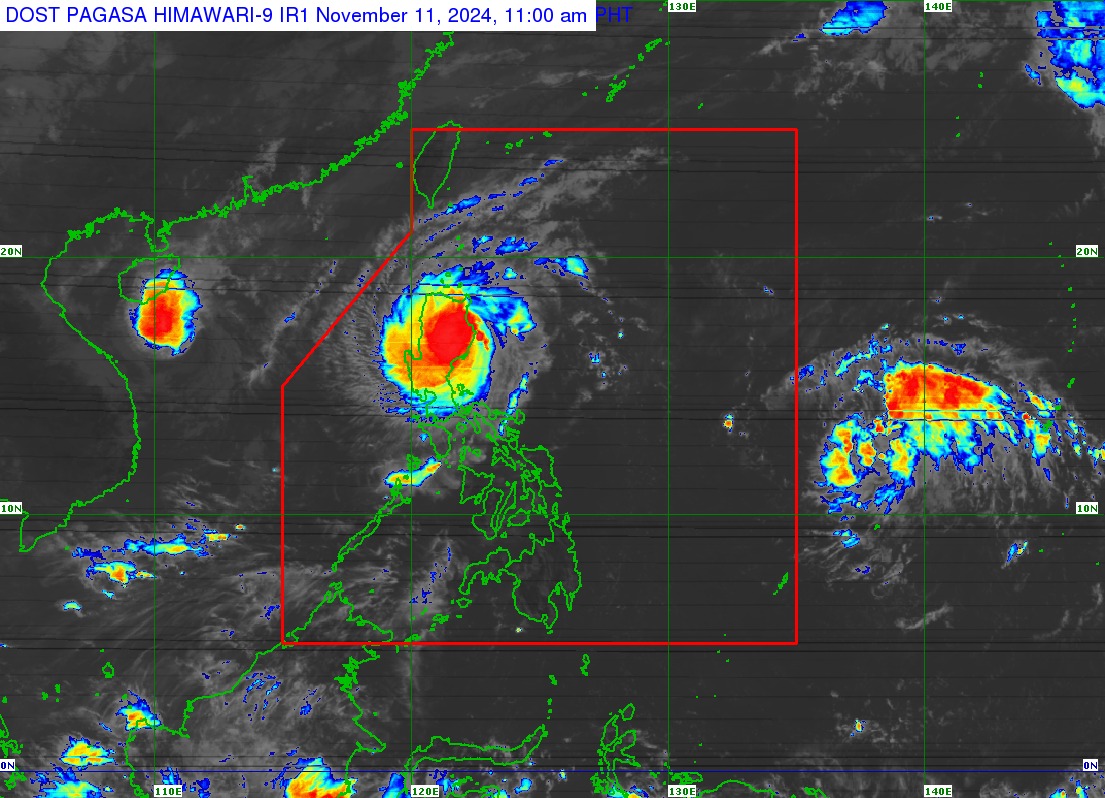
Typhoon Nika (international name: Toraji) made a landfall in the vicinity of Dilasag, Aurora on Monday morning while two tropical cyclones outside the Philippine area of responsibility (PAR) threaten the country, the state weather bureau said.
In its tropical cyclone bulletin issued at 11:00 a.m., the Philippine Atmospheric, Geophysical and Astronomical Services Administration (PAGASA) said the eye of “Nika” was located in the vicinity of San Agustin, Isabela, moving northwestward at 25 kilometers per hour.
The typhoon packs maximum sustained winds of 130 kph near the center and gustiness of up to 180 kph.
Tropical Cyclone Wind Signal (TCWS) No. 4 remains hoisted in the following areas:
- Northernmost portion of Aurora (Dilasag, Casiguran)
- Central and southern portions of Isabela (Dinapigue, San Mariano, San Guillermo, Jones, Echague, Ramon, San Isidro, City of Santiago, Cordon, Roxas, Burgos, Reina Mercedes, Naguilian, Benito Soliven, Gamu, San Manuel, Aurora, San Mateo, Cabatuan, Alicia, Luna, City of Cauayan, Angadanan, Quezon, Mallig, Quirino, Ilagan City, Delfin Albano, San Agustin)
- Kalinga
- Mountain Province
- Northern portion of Ifugao (Aguinaldo, Mayoyao, Alfonso Lista, Banaue, Hungduan, Hingyon, Lagawe)
- Central and southern portion of Abra (Manabo, Pidigan, San Juan, Tayum, Langiden, Luba, Boliney, Sallapadan, Bucloc, Lagangilang, Tubo, Danglas, Villaviciosa, La Paz, Licuan-Baay, Pilar, Malibcong, Pe, San Isidro, Daguioman, San Quintin, Dolores, Lagayan, Bangued, Bucay, Lacub)
- Northern and central portions of Ilocos Sur (Cabugao, Sinait, San Juan, San Emilio, Lidlidda, Banayoyo, Santiago, San Esteban, Burgos, Santa Maria, Magsingal, San Vicente, Santa Catalina, Nagbukel, San Ildefonso, City of Vigan, Caoayan, Santa, Bantay, Santo Domingo, Narvacan, Quirino, Cervantes, Sigay, Salcedo, Santa Lucia, City of Candon, Galimuyod, Gregorio del Pilar, Santa Cruz)
TCWS No. 3 is raised in 11 areas:
- Central portion of Aurora (Dinalungan)
- Northern portion of Quirino (Diffun, Cabarroguis, Aglipay, Saguday, Maddela)
- Northeastern portion of Nueva Vizcaya (Diadi, Bagabag, Quezon, Solano, Villaverde, Kasibu, Ambaguio, Bayombong)
- Rest of Isabela
- Southwestern portion of Cagayan (Enrile, Solana, Tuao, Tuguegarao City, Rizal, Piat)
- Southern portion of Apayao (Conner, Kabugao)
- Rest of Abra
- Rest of Ifugao
- Northern portion of Benguet (Buguias, Mankayan, Bakun)
- Southern portion of Ilocos Norte (Laoag City, Sarrat, San Nicolas, Piddig, Marcos, Nueva Era, Dingras, Bacarra, Solsona, Paoay, Currimao, Pinili, Badoc, City of Batac, Banna)
- Rest of Ilocos Sur
TCWS No. 2 is likewise hoisted in 10 areas:
- Northwestern and eastern portions of Cagayan (Iguig, Peñablanca, Baggao, Alcala, Amulung, Santo Niño, Gattaran, Lasam, Santa Praxedes, Claveria, Sanchez-Mira, Pamplona, Abulug, Allacapan, Ballesteros, Lal-Lo, Aparri, Camalaniugan, Buguey, Santa Teresita, Gonzaga)
- Rest of Nueva Vizcaya
- Rest of Quirino
- Rest of Apayao
- Rest of Benguet
- Rest of Ilocos Norte
- La Union
- Northeastern portion of Pangasinan (San Nicolas, Natividad, San Quintin, Sison, San Manuel, Umingan, Tayug)
- Central portion of Aurora (Dipaculao, Maria Aurora, Baler)
- Northern portion of Nueva Ecija (Carranglan, Pantabangan, Lupao, San Jose City)
Metro Manila and parts of Central Luzon and Calabarzon are also placed under TCWS No. 1:
- Babuyan Islands
- Rest of mainland Cagayan
- Rest of Pangasinan
- Rest of Aurora
- Rest of Nueva Ecija
- Bulacan
- Pampanga
- Tarlac
- Northern and central portions of Zambales (Santa Cruz, Candelaria, Masinloc, Palauig, Iba, Botolan, Cabangan, San Marcelino, San Felipe, San Narciso)
- Metro Manila
- Rizal
- Eastern portion of Laguna (Santa Maria, Mabitac, Pakil, Pangil, Famy, Siniloan, Paete, Kalayaan, Cavinti, Lumban, Luisiana, Santa Cruz, Magdalena, Pagsanjan, Pila)
- Northern and eastern portions of Quezon (Infanta, Sampaloc, Mauban, Real, General Nakar) including Polillo Islands
In its track forecast, PAGASA said Nika will traverse the Luzon landmass and emerge over the sea east of Ilocos Sur by Monday afternoon or evening.
The tropical cyclone is forecast to move west-northwestward over the West Philippine Sea and may exit the PAR Tuesday morning or afternoon.
Meanwhile, the state weather bureau said the tropical depression outside the PAR was last spotted 1,480 km east of Eastern Visayas, moving west-northwestward at 35 kph. It packs winds of 55 kph near the center and gusts of up to 70 kph.
The tropical cyclone is forecast to enter the PAR Tuesday morning and will be given the name “Ofel”.
“On the forecast track, the TD may make landfall over Northern or Central Luzon on Thursday (Nov. 14) evening or Friday (Nov. 15) early morning,” PAGASA said.
Another weather disturbance, the Tropical Storm Man-Yi was located 3,280 km east of southeastern Luzon, also still outside the PAR.
—avds