
By Brian Campued
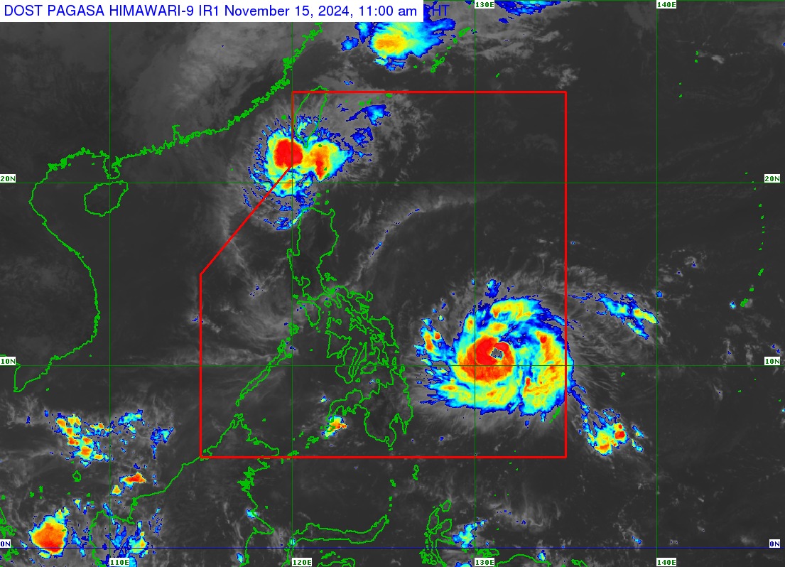
Severe Tropical Storm Pepito (international name: Man-yi) has rapidly intensified into a typhoon Friday morning over the Philippine Sea, according to the state weather bureau.
In its tropical cyclone bulletin issued at 11:00 a.m., the Philippine Atmospheric, Geophysical and Astronomical Services Administration (PAGASA) said “Pepito” was located 630 kilometers East of Guiuan, Eastern Samar, moving westward at 30 kilometers per hour.
The typhoon packs maximum sustained winds of 130 kph near the center and gustiness of up to 160 kph.
Residents in the following areas under Tropical Cyclone Wind Signal (TCWS) No. 2 are warned against gale-force winds:
- Eastern portion of Northern Samar (Mapanas, Gamay, Palapag, Lapinig)
- Northern portion of Eastern Samar (Arteche, Oras, San Policarpo, Dolores, Jipapad, Maslog).
Strong winds will likely be experienced over the areas under TCWS No. 1:
- Southeastern portion of Quezon
- Camarines Norte
- Camarines Sur
- Catanduanes
- Albay
- Sorsogon
- Masbate
- Rest of Northern Samar
- Rest of Eastern Samar
- Samar
- Biliran
The highest wind signal which may be hoisted during the occurrence of Pepito is TCWS No. 5.
Based on the cyclone’s track forecast, Pepito will continue to rapidly intensify to super typhoon category prior to landfall in the vicinity of Catanduanes Saturday evening (Nov. 16) or Sunday morning (Nov. 17).
However, PAGASA said, other landfall scenarios over other areas are possible due to the typhoon’s cone of probability.
“Landfall scenario over the eastern coast of Camarines Sur, Albay, or Sorsogon during the same time frame, over the eastern coast of Northern Samar tomorrow afternoon or evening (Nov. 16), or along the eastern coast of Quezon or Aurora on Sunday afternoon or evening (Nov. 17) remains not ruled out,” the agency said.
Regardless of its landfall point, Pepito is expected to move generally west-northwestward over the weekend, affecting most of Luzon, including Metro Manila.
Meanwhile, both Pepito and Severe Tropical Storm Ofel will bring moderate to heavy rains in Batanes until Saturday noon.
By Sunday, intense to torrential rains will be experienced in Catanduanes, Albay, Sorsogon, and Northern Samar; heavy to intense rains over Eastern Samar, Caramines Sur, and Camarines Norte; and moderate to heavy rains in Masbate Leyte, Quezon, Samar, and Biliran.
From Sunday noon to Monday (Nov. 18), more areas in Luzon will experience heavy to torrential rains, especially in Bicol, Central Luzon, Metro Manila, Calabarzon, and Mimaropa.
A storm surge warning is also hoisted over the low-lying, coastal localities of southeastern Quezon, Camarines Sur, Catanduanes, Albay, Sorsogon, northern Masbate (including Burias and Ticao Islands), Northern Samar, Eastern Samar, Samar, and northern Biliran in the next 48 hours.
—iro