By Brian Campued
Tropical Depression Verbena is forecast to intensify into a tropical storm by Tuesday night, according to the Philippine Atmospheric, Geophysical and Astronomical Services Administration (PAGASA).
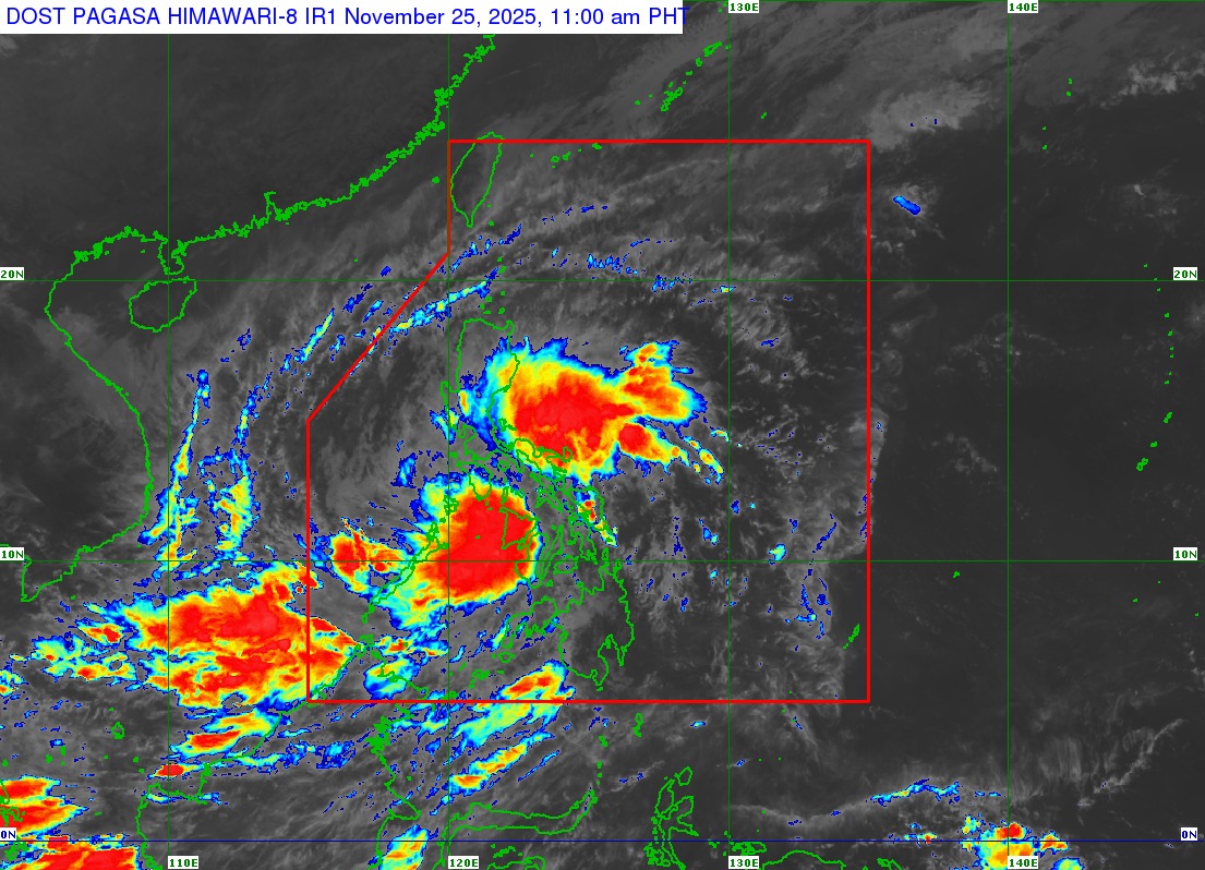
As of 10:00 a.m., the center of Verbena was located over the coastal waters of Hamtic, Antique after it passed over Guimaras and southwestern Panay.
It packs maximum sustained winds of 55 kph and gustiness of up to 90 kph, and is moving west-northwestward at 35 kph.
“Mapapansin po natin na ‘yung malawak na kaulapan ng Bagyong Verbena, talagang nasasakupan ang nakararaming bahagi ng Visayas, nakararaming bahagi ng southern Luzon, at maging ilang bahagi ng Mindanao,” PAGASA Asst. Weather Services Chief Chris Perez said in a public briefing.
Due to this, Tropical Cyclone Wind Signal (TCWS) No. 1 remains hoisted in the following areas which may experience strong winds within the next 36 hours:
- Occidental Mindoro
- Oriental Mindoro
- Romblon
- Northern and central portions of Palawan (Araceli, Taytay, El Nido, Dumaran, Roxas, San Vicente, and Puerto Princesa City), including Calamian, Cuyo, and Cagayancillo Islands
- Mainland Masbate (Balud, Mandaon, Milagros, Cawayan, Placer, Pio V. Corpuz, Esperanza, Uson, Dimasalang, City of Masbate, Mobo, Palanas, Aroroy, Cataingan, and Baleno)
- Antique
- Aklan
- Capiz
- Iloilo
- Guimaras
- Negros Occidental
- Negros Oriental
- Cebu
Verbana will also bring heavy to intense rains over Occidental Mindoro, Oriental Mindoro, Romblon, Palawan, Antique, Aklan, Capiz, Iloilo, and Guimaras until Wednesday noon (Nov. 26); moderate to heavy rains are likely in Marinduque, Masbate, Negros Occidental, and Negros Oriental during the same forecast period.
“Ang nabanggit po nating lugar, patuloy pa ring makakaranas ng mga pag-ulan at paminsan-minsang pagbugso ng hangin. Samantala, ang mga baybaying-dagat sa kapaligiran nito [ay] magiging katamtaman hanggang sa maalon—hangga’t maaari huwag munang pumalaot ang anumang uri ng sasakyang-pandagat habang nandito pa sa area na ito ang Tropical Depression Verbena,” Perez said.
Based on the track forecast, the tropical cyclone may make landfall over the northern portion of Palawan on Tuesday night before emerging over the West Philippine Sea early Wednesday morning. It will exit the Philippine area of responsibility (PAR) on Thursday (Nov. 27).
PAGASA noted that Verbena may also reach its peak intensity on late Thursday or early Friday (Nov. 28) while over the West Philippine Sea.
As a gale warning remains in effect over the seaboards of Northern Luzon, mariners of small seacrafts are advised to remain in port or seek safe harbor due to rough to very rough sea conditions.
Meanwhile, the shear line—or the area where cold and warm winds converge—will dump heavy to intense rains over Cagayan, Isabela, Aurora, Quezon, and Camarines Norte until Wednesday noon.
Moderate to heavy rains will also drench Apayao, Kalinga, Mountain Province, Ifugao, Nueva Vizcaya, Quirino, Bulacan, Metro Manila, Rizal, Cavite, Laguna, Batangas, Camarines Sur, Catanduanes, Albay, and Sorsogon until Wednesday noon due to the shear line.
Flooding and landslides may be expected in the said areas.
-jpv
