By Brian Campued
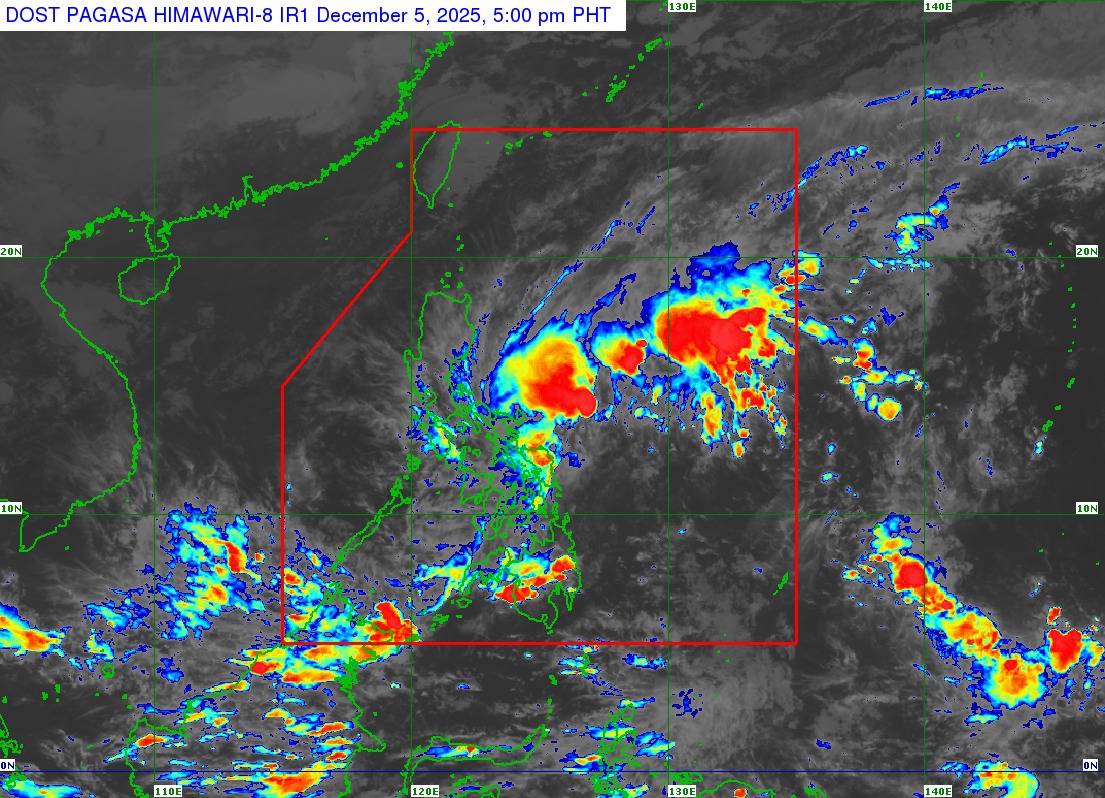
The combined effects of Tropical Depression Wilma and the shear line will bring heavy to intense rains over parts of Eastern Visayas and Bicol Region until Saturday, the state weather bureau said Friday.
In its heavy rainfall outlook issued at 5:00 p.m., the Philippine Atmospheric, Geophysical and Astronomical Services Administration (PAGASA) said Wilma is forecast to drench Northern Samar, Eastern Samar, Samar, Biliran, and Leyte while the shear line will persist over Camarines Sur, Catanduanes, Albay, Sorsogon, and Masbate.
Moderate to heavy rains are also expected over Southern Leyte, Cebu, Bohol, Negros Oriental, Negros Occidental, Siquijor, Aklan, Capiz, Iloilo, Guimaras, Surigao del Norte, Dinagat Islands, Romblon, and Camarines Norte until Saturday afternoon.
Flooding and landslides are possible in the abovementioned provinces, especially in areas already drenched by recent typhoons.
As of 4:00 p.m., the center of Tropical Depression Wilma was located 180 km east of Borongan City, Eastern Samar. It packs maximum sustained winds of 45 kph and gustiness of up to 55 kph while moving westward slowly.
Based on the track forecast, Wilma will continue to move slowly until it makes landfall over Eastern Samar on Saturday. It will traverse Visayas until Sunday (Dec. 7) and Palawan on Monday (Dec. 8) before exiting the Philippine area of responsibility on Tuesday (Dec. 9).
PAGASA weather specialist Benison Estareja explained that Wilma’s slow movement is due to the prevailing high pressure area from mainland Asia.
“Kapag meron tayong high pressure area, napipigilan yung pagkilos o pag-usad ng bagyo kaya naman posibleng manatili at mababad po sa mga pag-ulan ang ating mga kababayan po dito sa may silangang bahagi ng Kabikulan at ng Visayas,” Estareja said.
The state meteorologist noted that the presence of the cold and dry winds from the northeast monsoon (amihan) will also prevent Wilma from intensifying into a tropical storm throughout the forecast period. Interaction with the landmass may also weaken the cyclone.
“The moment na magkaroon ng interaksiyon sa kalupaan, nagkakaroon ng frictional effects kung saan nasisira yung sirkulasyon ng bagyo. So hindi natin inaalis yung possibility na habang binabagtas po nitong si Bagyong Wilma ang kalupaan ng Visayas ay mag-downgrade po tayo into a low pressure area,” Estareja said.
Tropical Cyclone Wind Signal (TCWS) No. 1 remains hoisted in southern Bicol, most of Visayas, and the northern portion of Mindanao. Residents in these localities are advised to prepare for the strong winds brought by Wilma, which may be felt within the next 36 hours from the time of issuance.
The areas under TCWS No. 1 are the following:
- Southern portion of Sorsogon (Matnog, Bulan, Irosin, Santa Magdalena, Bulusan, Barcelona, Magallanes, Juban, Casiguran, and Gubat)
- Mainland Masbate including Ticao Island
- Northern Samar
- Eastern Samar
- Samar
- Biliran
- Leyte
- Southern Leyte
- Cebu including Bantayan and Camotes Islands
- Bohol
- Northern and central portions of Negros Occidental (Sagay City, City of Escalante, Toboso, Calatrava, Enrique B. Magalona, City of Victorias, Manapla, Cadiz City, Bacolod City, City of Talisay, Silay City, Salvador Benedicto, San Carlos City, Murcia, Bago City, La Carlota City, La Castellana, Moises Padilla, Valladolid, Pulupandan, San Enrique, Pontevedra, Hinigaran, Isabela, Binalbagan, City of Himamaylan, City of Kabankalan),
- Siquijor
- Northern and central portions of Negros Oriental (City of Guihulngan, Canlaon City, Vallehermoso, La Libertad, Jimalalud, Tayasan, Ayungon, Bindoy, Manjuyod, Bais City, Pamplona, City of Tanjay, Amlan, San Jose, Dumaguete City, Valencia, Sibulan, Bacong, Mabinay)
- Northern and central portions of Iloilo (San Dionisio, Estancia, Batad, Carles, Concepcion, Ajuy, Sara, Balasan, Lemery, Barotac Viejo, San Rafael, City of Passi, San Enrique, Anilao, Banate, Dingle, Barotac Nuevo, Mina, Pototan, New Lucena, Santa Barbara, Pavia, Iloilo City, Leganes, Zarraga, Dumangas, Dueñas, Bingawan)
- Eastern and central portions of Capiz (Pilar, President Roxas, Panay, Pontevedra, Ma-Ayon, Cuartero, Dumarao, Dao, Panitan, Roxas City, Ivisan, Sigma, Sapi-An, Mambusao, Dumalag)
- Guimaras
- Surigao del Norte including Siargao and Bucas Grande Islands
- Dinagat Islands
- Northern portion of Surigao del Sur (Carrascal, Cantilan, Madrid, Carmen, Lanuza)
- Northern portion of Agusan del Norte (Kitcharao, Jabonga, Santiago, Tubay, City of Cabadbaran, Remedios T. Romualdez, Magallanes)
- Camiguin
The state weather bureau also warned against sea travel, especially for small seacrafts, as waves may reach as high as 5.5 meters over the seaboards on the eastern coasts of Cagayan, Isabela, Aurora, northern coast of Quezon including Polillo Islands, Camarines Norte, northern coast of Camarines Sur, eastern coasts of Albay and Sorsogon, Catanduanes, Northern Samar, and Eastern Samar.
The rough to very rough sea conditions in the said areas are caused by amihan and Tropical Depression Wilma.
-jpv
