
By Dean Aubrey Caratiquet
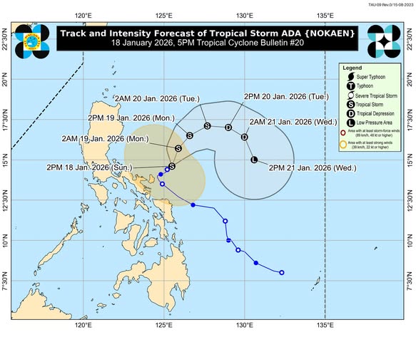
Tropical Storm Ada slightly weakened and changed its course as it continues to hover over the waters of Catanduanes, according to the Philippine Atmospheric, Geophysical and Astronomical Services Administration’s (PAGASA) 5:00 p.m. bulletin.
Ada (international name: Nokaen) was last located 205 km northeast of Virac, Catanduanes, packing maximum sustained winds of 65 kph and gustiness of up to 80 kph, as it slowly moves northeastward.
The weakening of the tropical cyclone has prompted the state weather bureau to lift Tropical Cyclone Wind Signal (TCWS) No. 2.
Moreover, TCWS No.1 is hoisted in Catanduanes and the northeastern portion of Camarines Sur (Garchitorena, Lagonoy, Presentacion, Caramoan, San Jose, Siruma, Tinambac), which are expected to experience strong winds over the next 36 hours.
In the 2:00 p.m. update, PAGASA warns of a minimal to moderate risk of storm surge, with up to 2.0 meter waves possibly reaching the low-lying coastal areas of Camarines Sur and Catanduanes over the next 24 hours.
The state weather bureau, meanwhile, lifted all previous gale warning advisories, but still advises fisherfolk and owners of small marine vessels against sailing due to rough seas over the following coastal waters:
• Up to 4.0 m: The seaboard of Isabela; the eastern seaboard of mainland Cagayan.
• Up to 3.5 m: The seaboard of Batanes, Babuyan Islands, and Camarines Norte; the northern seaboards of Camarines Sur and Catanduanes; the eastern seaboard of Polillo Islands
• Up to 3.0 m: The seaboard of Aurora, Ilocos Norte, and Ilocos Sur; the western seaboard of Pangasinan; the eastern seaboard of Catanduanes.
Ada is expected to maintain its course until Monday (Jan. 19), but may eventually follow a looping track over the Philippine Sea. It will remain as a tropical storm before weakening into a tropical depression by Tuesday (Jan. 20).
Further weakening into a low pressure area may also take place by Wednesday (Jan. 21) due to the surge of the northeast monsoon.
av