
By Brian Campued
Typhoon Francisco (international name: Mekkhala) continues to weaken while nearing its exit from the Philippine area of responsibility (PAR), as another tropical cyclone is forecast to enter the country on Thursday (June 25), according to the Philippine Atmospheric, Geophysical and Astronomical Services Administration (PAGASA).
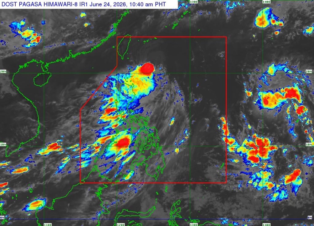
Based on the latest tropical cyclone bulletin issued by PAGASA as of 11:00 a.m. Wednesday, “Francisco” was last seen 295 km east-northeast of Basco, Batanes. It is moving northward at 10 kph with maximum sustained winds of 140 kph near the center and gustiness of up to 170 kph.
“Yung direktang epekto ng Bagyong Francisco naka-concentrate pa rin sa may Batanes at Cagayan provinces habang yung outer rainbands nitong bagyo umaabot na rin sa natitirang bahagi ng Cagayan Valley, Cordillera Region, at Ilocos Region,” PAGASA Weather Specialist Benison Estareja said in a public briefing.
Due to the typhoon’s radius which extends to the extreme northern Luzon, PAGASA said Tropical Cyclone Wind Signal (TCWS) No. 1 remains hoisted over Bataan and the northeastern portion of Cagayan (Gonzaga and Santa Ana), including Babuyan Islands.
“Ibig sabihin po for today, pabugso-bugso pa rin po yung hangin na malalakas at posible itong makasira ng ilang pananim at posible ring makasira ng mga istruktura na yari sa mga very light materials,” Estareja said.
Based on PAGASA’s track forecast, Francisco will continue moving northward until Thursday before turning north-northeast towards the Ryukyu Islands and sea south of mainland Japan. It will exit the PAR by Thursday evening.
In terms of heavy rains, the state weather bureau said Francisco will bring 50 to 100 mm of rainfall over Batanes and Cagayan until Thursday noon, while the southwest monsoon (habagat) will drench Zambales, Bataan, Occidental Mindoro, Palawan, and Antique.
“Ang equivalent po ng 50 to 100 mm na dami ng ulan ay posibleng magdulot pa rin ng mga pagbaha sa mga low-lying areas at yung malalapit sa mga kailogan, at posible ring mag-cause yung ganitong karaming ulan ng pagguho ng lupa sa mga bulubundukin na lugar,” Estareja explained.
PAGASA also warned against sea travel for all types of sea vessels as waves may reach as high as 4.5 meters over Batanes and northeastern coast of Cagayan including Babuyan Islands within the next 24 hours.
“Equivalent po yan sa isa’t kalahating palapag na gusali so napakataas po ng mga pag-alon na ito, delikado for all types of sea vessels, most likely po pagbabawalan pa rin po kayong pumalaot hanggang ngayon,” Estareja said.
Meanwhile, a tropical storm with the international name “Higos” was monitored 2,120 km east of Central Luzon. It packs maximum sustained winds of 65 kph and gustiness of up to 80 kph while moving west-northwestward at 20 kph.
The tropical storm is forecast to enter the PAR by Thursday evening and will be given the local name “Gardo,” the third tropical cyclone in the country this June.
“So nandyan yung possibility na paglabas mismo nitong Bagyong Francisco ay saka naman po papasok itong panibagong bagyo at ito yung tatawagin natin Gardo,” Estareja said.
He added that the weather disturbance is unlikely to make landfall, have a direct effect on the country, or enhance the habagat.
While over the Philippine Sea, Gardo will turn generally northward and exit the PAR by Friday morning or afternoon.
-jpv