
By Brian Campued
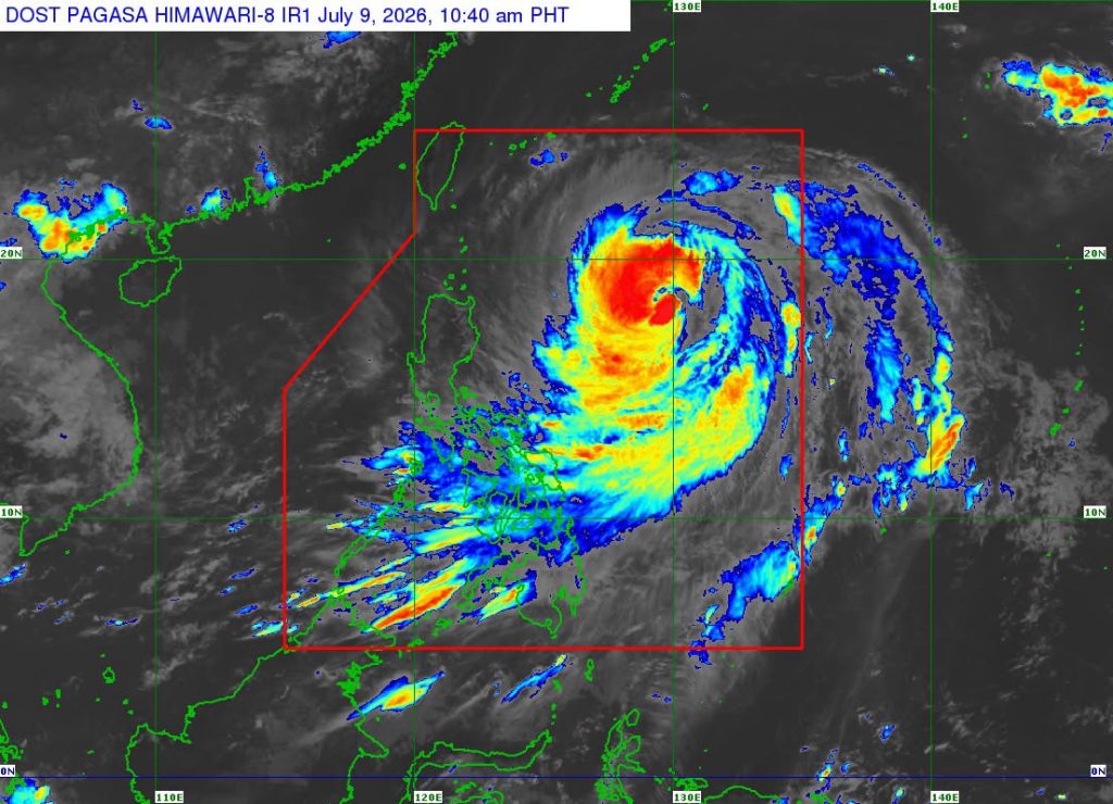
Tropical Cyclone Wind Signal (TCWS) No. 2 has been raised over Batanes on Thursday as “Inday” (international name: Bavi) approaches the extreme northern Luzon despite weakening into a typhoon from super typhoon category.
According to the Philippine Atmospheric, Geophysical and Astronomical Services Administration’s (PAGASA) 11:00 a.m. update, Inday was located 865 km east of northern Luzon. It is packing maximum sustained winds of 165 kph near its center and gustiness of up to 205 kph, while moving northwestward at 15 kph.
“Bagama’t offshore o nasa dagat pa rin yung tinatayang sentro ng typhoon na si Inday ay yung makakapal na kaulapan nito tumatama na sa silangang bahagi ng Luzon, in particular,” PAGASA Asst. Weather Services Chief Chris Perez said in an online briefing.
“Samantala yung pinag-ibayong habagat naman, yung mga kaulapan nito, umaabot na sa Palawan, nakararaming bahagi ng Visayas, at sa kanlurang bahagi ng Mindanao,” Chief Perez added.
Aside from TCWS No. 2, Wind Signal No. 1 has also been raised over the following areas in Luzon:
- Cagayan, kasama ang Babuyan Islands
- Isabela
- Northeastern portion of Quirino (Maddela)
- Apayao
- Northern portion of Abra (Tineg, Lagayan, Danglas, San Juan, Lagangilang, Licuan-Baay, Malibcong, Lacub, Daguioman, Dolores, at La Paz)
- Kalinga
- Eastern portion of Mountain Province (Natonin at Paracelis)
- Eastern portion of Ifugao (Aguinaldo at Alfonso Lista)
- Ilocos Norte
- Northern portion of Aurora (Dilasag at Casiguran)
- Northern and central portions of Catanduanes (Pandan, Caramoran, Bagamanoc, Panganiban, Viga, Gigmoto, Baras at San Miguel)
Perez warned residents in Batanes of gale-force winds (62-88 kph) within the next 24 hours that may pose minor to moderate threat to life and property. Those in areas under TCWS No. 1 may expect strong winds (39-61 kph) within the next 36 hours.
Inday is forecast to generally move northwestward while remaining over the Philippine Sea and may pass closest to extreme northern Luzon between Friday evening, July 10, and Saturday morning, July 11, before exiting the Philippine area of responsibility (PAR) on the same day.
In terms of rainfall, the state weather bureau said Inday will bring moderate to heavy rains (50-100 mm) over Batanes between Friday noon to Saturday noon, when the typhoon is nearest to the extreme northern Luzon area.
Meanwhile, the enhanced southwest monsoon will drench Occidental Mindoro, Antique, Negros Occidental, Zamboanga del Sur, Lanao del Norte, and Lanao del Sur until Friday noon.
Beginning Friday noon until Saturday noon, heavy to intense rains (100-200 mm) are expected over Occidental Mindoro and Antique, and moderate to heavy rains in Zambales, Bataan, Cavite, Batangas, Oriental Mindoro, Romblon, Palawan, Aklan, Capiz, Iloilo, Guimaras, Negros Occidental, Negros Oriental, Zamboanga del Sur, Lanao del Norte, and Lanao del Sur.
Heavy to intense rains are also forecast over Occidental Mindoro, Zambales, and Bataan from Saturday noon to Sunday noon, July 12, and moderate to heavy rains in Pangasinan, La Union, Tarlac, Pampanga, Bulacan, Metro Manila, Rizal, Cavite, Batangas, Oriental Mindoro, Romblon, Palawan, Aklan, and Antique.
“Patuloy pa ring paalala natin na mag-monitor sa local conditions. Maging alerto sa mga posibleng pagbaha, lalong-lalo na sa mga low-lying areas. Sa mga lugar na malapit sa gilid ng ilog, maaaring tumaas yung lebel ng tubig dahil sa continuous na ulan at magdulot ng mga pagbaha,” Chief Perez said, adding that landslides are also likely over highly-susceptible areas.
Gale warning is also hoisted over the northern and eastern seaboards of Batanes, the northern and eastern coasts of Cagayan including Babuyan Islands, Isabela, Aurora, the northern and eastern coasts of Catanduanes, Polillo Islands, the eastern coast of Camarines Norte, the northern coast of Camarines Sur, and the northern and eastern coast of Northern Samar.
“As much as possible, huwag nang pumalaot ang anumang uri ng sasakyang pandagat,” Perez told mariners.
-jpv

