
By Dean Aubrey Caratiquet
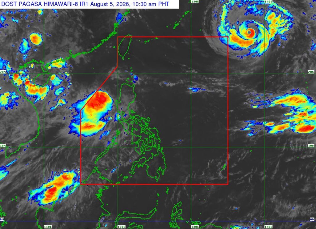
After intensifying into a tropical storm, Maymay changed direction as it continues to hover over the sea west of La Union.
According to PAGASA’s 11:00 a.m. bulletin on Wednesday, the weather system was last located 185 km west northwest of Bacnotan, La Union, packing maximum sustained winds of 65 kph and gustiness of 80 kph as it moves northward at 10 kph.
Tropical Cyclone Wind Signal No. 2 was hoisted by PAGASA in the following areas, which may experience gale-force winds over the next 24 hours:
- Ilocos Sur
- Northern and central portions of La Union (Luna, Caba, Santol, Bauang, City of San Fernando, San Juan, Bagulin, Aringay, Bangar, San Gabriel, Burgos, Naguilian, Bacnotan, Sudipen, and Balaoan)
- Northwestern portion of Pangasinan (Anda, Bolinao, and Bani)
- Southwestern portion of Abra (Manabo, Pidigan, Langiden, Luba, Boliney, Sallapadan, Bucloc, Tubo, Villaviciosa, Pilar, Peñarrubia, San Isidro, San Quintin, Bangued, Bucay, Danglas, La Paz, and Tayum)
- Western portion of Mountain Province (Besao, Tadian, Bauko, Sagada, and Sabangan)
- Northwestern portion of Benguet (Mankayan, Kapangan, Kibungan, Sablan, and Bakun)
- La Union (Luna, Caba, Santol, Bauang, City of San Fernando, San Juan, Bagulin, Aringay, Bangar, San Gabriel, Burgos, Naguilian, Bacnotan, Sudipen, and Balaoan)
TCWS No. 1 is also raised over the following areas, which may experience 39-61 kph winds over the next 36 hours:
- Ilocos Norte
- Rest of La Union
- Rest of Pangasinan
- Apayao
- Rest of Abra
- Kalinga
- Rest of Mountain Province
- Ifugao
- Rest of Benguet
- Cagayan
- Isabela
- Quirino
- Nueva Vizcaya
- Northern portion of Zambales (Candelaria, Santa Cruz, Masinloc, and Palauig)
- Northern portion of Tarlac (Mayantoc, San Clemente, Camiling, Santa Ignacia, Gerona, Paniqui, Moncada, San Manuel, Anao, Ramos, and Pura)
- Northern portion of Nueva Ecija (Carranglan, Lupao, Cuyapo, Talugtug, Nampicuan, Guimba, Science City of Muñoz, San Jose City, and Pantabangan)
- Northern and central portions of Aurora (Dilasag, Casiguran, Dinalungan, and Dipaculao)
PAGASA likewise issued a gale warning advisory for the western seaboard of northern Luzon (Ilocos Sur, La Union, and Pangasinan), noting rough to very rough seas that can generate waves 2.8-4.5m high.
The state weather bureau likewise advises fisherfolk and owners of small marine vessels to exercise caution when venturing into open water, due to rough seas over the following coastal areas:
- Up to 3.5 m: The seaboard of northern Zambales
- Up to 3.0 m: The seaboards of Isabela and Lubang Islands; the northern and eastern seaboards of Batanes and Catanduanes; the western seaboards of Ilocos Norte, Bataan, Cavite, and Batangas; the northern seaboards of Camarines Norte and Camarines Sur; the eastern seaboard of Davao Oriental; the remaining seaboard of Zambales
Maymay is expected to move generally eastward and may make landfall over Ilocos Sur or La Union by afternoon or evening, before crossing the landmass of northern and Central Luzon until Thursday (Aug. 6).
The weather system is also forecast to remain as a Tropical Storm as it nears the Philippine landmass, before weakening into a tropical depression on Thursday morning.
PAGASA, moreover, urged the public and disaster risk reduction and management offices to facilitate preparations, implement salient protocols, and continue monitoring further developments issued by the state weather bureau.
jpv

