
By Brian Campued
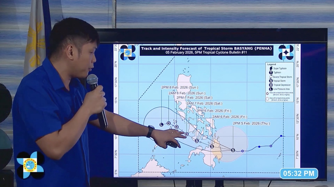
Tropical Storm Basyang (international name: Penha) is forecast to further intensify before making its initial landfall over Surigao del Sur this Thursday evening or early Friday morning, according to the state weather bureau.
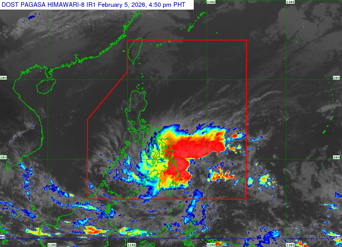
In its 5:00 p.m. update, the Philippine Atmospheric, Geophysical and Astronomical Services Administration (PAGASA) said Basyang was located 150 km east of Hinatuan, Surigao del Sur. It is moving west-northwestward at 25 kph with winds of 75 kph and gusts of up to 90 kph.
“Papalapit pa nga po ito nang papalapit sa ating kalupaan. At ayon sa ating forecast track, ito ay posibleng mag-landfall sa southern portion ng Surigao del Sur ngayong gabi, at kung mas babagal pa ito ay posible rin na bukas ng umaga yung landfall niya,” PAGASA weather specialist John Manalo said.
Based on the forecast track, the tropical cyclone may also pass close to or make another landfall over Siquijor and the southern portion of Negros Oriental by Friday afternoon or evening, Feb. 6.
Interaction with the landmass will gradually weaken Basyang into a tropical depression by Saturday, Feb. 7, and low pressure area by Sunday, Feb. 8.
Residents in Caraga as well as parts of Northern Mindanao, Central Visayas, and Negros Island Region are urged to prepare for possible gale-force winds within the next 24 hours. The following areas are under Tropical Cyclone Wind Signal (TCWS) No. 2:
- Siquijor
- Southern portion of Negros Oriental (Dumaguete City, San Jose, Valencia, Bacong, Amlan, Dauin, Sibulan, Zamboanguita, Siaton, City of Tanjay, Pamplona, Santa Catalina, Bais City, Manjuyod, Bindoy, City of Bayawan, Basay, Mabinay, Ayungon, Tayasan, Jimalalud, and La Libertad)
- Southern portion of Negros Occidental (Candoni, City of Sipalay, Ilog, City of Kabankalan, Cauayan, Hinoba-An, City of Himamaylan, and Binalbagan)
- Southern portion of Cebu (Samboan, Malabuyoc, Oslob, Ginatilan, Alegria, Dalaguete, Boljoon, Alcoy, Santander, Argao, Badian, Moalboal, Ronda, Alcantara, Sibonga, and Dumanjug)
- Southern portion of Bohol (Bilar, Guindulman, Antequera, Sevilla, Loboc, Tagbilaran City, Maribojoc, Pilar, Jagna, Lila, Corella, Loon, Dimiao, Candijay, Alburquerque, Anda, Dauis, Sikatuna, Baclayon, Batuan, Loay, Valencia, Garcia Hernandez, Carmen, Panglao, Duero, Cortes, Balilihan, Sierra Bullones, Catigbian, San Isidro, Calape, Mabini, Alicia, Tubigon, Sagbayan, and Clarin)
- Surigao del Norte, including Siargao – Bucas Grande Islands
- Surigao del Sur
- Extreme northern portion of Davao Oriental (Boston)
- Agusan del Norte
- Agusan del Sur
- Misamis Oriental
- Northern portion of Bukidnon (Impasug-Ong, Manolo Fortich, Malitbog, Sumilao, Libona, Baungon, City of Malaybalay, and Cabanglasan)
- Northeastern portion of Lanao del Norte (Iligan City)
- Northeastern portion of Misamis Occidental (Baliangao, Plaridel, Lopez Jaena, Oroquieta City, Calamba, Aloran, and Panaon)
- Camiguin
Strong winds are likewise expected over the following areas under Wind Signal No. 1 within the next 36 hours:
- Southern portion of Occidental Mindoro (San Jose, Magsaysay, Rizal, and Calintaan)
- Southern portion of Oriental Mindoro (Mansalay and Bulalacao)
- Southern portion of Romblon (Ferrol, Looc, Alcantara, Santa Fe, and San Jose)
- Northern portion of Palawan (Taytay, El Nido, Dumaran, and Araceli), including Calamian, Cuyo, and Cagayancillo Islands
- Southern portion of Eastern Samar (Guiuan, Salcedo, Mercedes, Giporlos, Balangiga, Lawaan, Quinapondan, General Macarthur, Hernani, Llorente, and Balangkayan)
- Southern portion of Samar (Marabut, Basey, and Santa Rita)
- Biliran
- Leyte
- Southern Leyte
- Rest of Bohol
- Rest of Cebu
- Rest of Negros Oriental
- Rest of Negros Occidental
- Guimaras
- Iloilo
- Capiz
- Aklan
- Antique
- Dinagat Islands
- Northern and central portions of Davao Oriental (Cateel, Baganga, Caraga, Manay, Tarragona, Lupon, and Banaybanay)
- Davao de Oro
- Davao del Norte
- Northern portion of Davao del Sur (Davao City)
- Rest of Bukidnon
- Northern portion of Cotabato (Carmen, Banisilan, Alamada, President Roxas, Antipas, Arakan, Magpet, Matalam, and Kabacan)
- Lanao del Sur
- Northern portion of Maguindanao del Norte (Buldon, Barira, and Matanog)
- Rest of Lanao del Norte
- Rest of Misamis Occidental
- Eastern and central portions of Zamboanga del Norte (Mutia, Piñan, Polanco, Dipolog City, Dapitan City, Sibutad, Rizal, La Libertad, Labason, Kalawit, Liloy, Salug, Bacungan, Sindangan, Jose Dalman, Manukan, Pres. Manuel A. Roxas, Katipunan, Sergio Osmeña Sr., Siayan, Godod, Tampilisan, and Gutalac)
- Northern and central portions of Zamboanga del Sur (Bayog, Kumalarang, Lapuyan, San Miguel, Guipos, Dinas, San Pablo, Dumalinao, Pagadian City, Tigbao, Lakewood, Dumingag, Mahayag, Molave, Josefina, Tambulig, Aurora, Ramon Magsaysay, Sominot, Midsalip, Labangan, and Tukuran)
- Northern portion of Zamboanga Sibugay (Kabasalan, Diplahan, Naga, Titay, Ipil, and Buug)
Meanwhile, Basyang will bring intense to torrential rains over Surigao del Sur, Agusan del Norte, Agusan del Sur, Misamis Oriental, and Camiguin until Friday afternoon.
Heavy to intense rains are likewise forecast in Southern Leyte, Cebu, Bohol, Negros Occidental, Negros Oriental, Siquijor, Dinagat Islands, Surigao del Norte, Misamis Occidental, Lanao del Norte, Lanao del Sur, Bukidnon, Davao del Norte, Davao de Oro, and Davao Oriental.
Leyte, Eastern Samar, Antique, Aklan, Capiz, Iloilo, Guimaras, Zamboanga del Norte, Zamboanga del Sur, Zamboanga Sibugay, Maguindanao del Norte, Cotabato, and Davao del Sur will experience moderate to heavy rains.
Flooding and landslides are expected, especially in low-lying areas and mountainous localities, PAGASA warned.
A Gale Warning is also in effect over the eastern and central seaboards of Visayas and the northern and eastern seaboards of Mindanao. Mariners of small vessels are advised to remain in port or seek safe harbor due to rough to very rough sea conditions in these areas.
“Mag-ingat po tayo. Posible po na umabot ng 5.5 meters yung taas ng alon, lalo na sa Surigao del Sur,” Manalo said.
Storm surge with peak heights of up to 2 meters may also affect the coastal communities in Occidental Mindoro. Oriental Mindoro, Romblon, Palawan including Calamian, Cuyo, and Cagayancillo Islands, Antique, Aklan, Capiz, Iloilo, Guimaras, Negros Occidental, Negros Oriental, Cebu, Bohol, Guimaras, Siquijor, Southern Leyte, Leyte, Camiguin, Dinagat Islands, Siargao and Bucas Grande Islands, Surigao del Norte, Surigao del Sur, Davao Oriental, Agusan del Norte, Misamis Oriental, Lanao del Norte, and Misamis Occidental within the next 48 hours.
PAGASA also urged the public to visit the Hazard Hunter website or access its mobile application to be informed if their locations are prone to floods, landslides, storm surges, and severe winds.
-av