
By Christine Fabro
Typhoon “Egay” is now outside the Philippine area of responsibility (PAR), the state weather bureau reported Thursday, July 27.
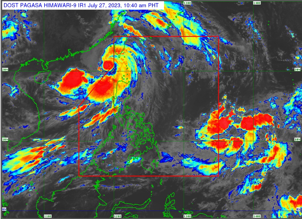
However, tropical cyclone wind signals (TCWS) are still hoisted over some parts of northern Luzon.
“Posibleng mangyari na kahit nasa labas na ng PAR ay mayroon pa rin tayong at least warning signal no. 1 sa ilang bahagi ng dulong-hilagang Luzon,” Philippine Atmospheric, Geophysical and Astronomical Services Administration (PAGASA) Assistant Weather Services Chief Chris Perez said in a briefing at 11:00 a.m. Thursday.
“Within the next 24 hours, inaasahan nating posibleng mag-landfall na dito sa may bandang southern part ng China, pero mapapansin natin ‘yung kurbada ng area of responsibility, may kalapitan pa rin dito sa ilang lugar sa dulong-hilagang Luzon,” he added.
TCWS No. 2 is raised over Batanes, northwestern portion of Cagayan (Claveria, Santa Praxedes) including Babuyan Islands and the northern portion of Ilocos Norte (Pagudpud, Adams, Bangui, Dumalneg, Burgos).
TCWS No. 1 is raised over Pangasinan, La Union, Ilocos Sur, the rest of Ilocos Norte, the rest of Cagayan, Apayao, Kalinga, Mountain Province, Ifugao, Abra, Benguet, Isabela, Quirino, Nueva Vizcaya, and northern portion of Aurora (Casiguran, Dinalungan, Dilasag).
Also under TCWS No. 1 are the northern portion of Nueva Ecija (Cuyapo, Guimba, Pantabangan, Science City of Muñoz, Carranglan, San Jose City, Lupao, Nampicuan, Talugtug), and the northern portion of Tarlac (Paniqui, Moncada, Pura, Camiling, Ramos, San Manuel, Anao, San Clemente).
“Egay” was last spotted at 255 kilometers (km) west of Itbayat, Batanes outside PAR with maximum sustained winds of 150 km per hour (km/h) near the center and gustiness of up to 185 km/h.
PAGASA said the southwest monsoon (habagat) enhanced by “Egay” will continue to bring occasional monsoon rains over the western portions of Central Luzon and Southern Luzon in the next three days.
According to PAGASA, another tropical depression is being monitored outside PAR.
“May isa naman tayong binabantayan na bagyo na nasa labas ng ating area of responsibility. Ang tropical depression na ito, nasa layong 1,585 kilometers pa, silangan ng Eastern Visayas. Wala pa itong direktang epekto sa kahit anong bahagi ng bansa,” Perez said.
Perez said the tropical depression may possibly enter PAR on Saturday night to Sunday morning, and will leave by Monday to Tuesday. – gb