
By Brian Campued
Heavy rains are expected to drench the western portions of the country as Typhoon Inday (international name: Bavi) enhances the southwest monsoon (habagat).
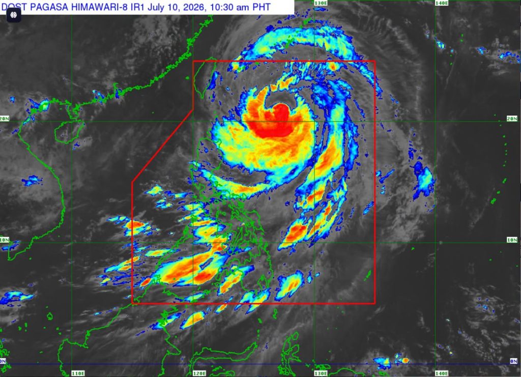
In its 11:00 a.m. bulletin on Friday, the Philippine Atmospheric, Geophysical and Astronomical Services Administration (PAGASA) said Inday continues to weaken as it moves northwestward at 20 kph over the sea east of Taiwan.
The typhoon was last located 570 km east of Itbayat, Batanes, packing maximum sustained winds of 140 kph near its center and gustiness of up to 170 kph.
According to PAGASA weather specialist Benison Estareja, Inday’s outer cloud bands are affecting Northern and Central Luzon, Quezon Province, and Bicol Region, bringing cloudy skies with occasional rains and gusts.
Despite the typhoon’s distance from the Extreme Northern Luzon, PAGASA has raised Tropical Cyclone Wind Signal (TCWS) No. 2 over Batanes, the eastern portion of Babuyan Islands (Babuyan Island, Didicas Island, Camiguin Island) , as well as the northeastern portion of mainland Cagayan (Santa Ana).
Areas under TCWS No. 2 may experience gale-force winds (62-88 kph) within the next 24 hours, which may pose a minor to moderate threat to life and property.

Meanwhile, strong winds (39-61 kph) may be felt within the next 36 hours in areas under Wind Signal No. 1:
- Rest of Babuyan Islands
- Rest of mainland Cagayan
- Isabela
- Apayao
- Northern portion of Abra (Tineg, Lagayan, Danglas, San Juan, Lagangilang, Licuan-Baay, Malibcong, Lacub, Daguioman, Dolores, and La Paz)
- Kalinga
- Eastern portion of Mountain Province (Natonin and Paracelis)
- Eastern portion of Ifugao (Aguinaldo, and Alfonso Lista)
- Ilocos Norte
The enhanced Southwest Monsoon and the periphery of Typhoon Inday will also bring strong to gale-force gusts over most of the country, especially in coastal and upland areas exposed to winds, until Saturday, July 11.
Gale warning has also been raised over the seaboards of Extreme Northern Luzon, particularly in Batanes and Babuyan Islands, as stormy weather conditions are expected to cause rough to high seas, with waves possibly reaching as high as 7 meters.
“Nasa isa hanggang sa dalawang palapag na gusali ang mga pag-alon po iyan. So, delikado ito for our small sea vessels, ‘yung ating mga nangingisda at maging sa mga malalaking sasakyang pandagat, challenging din ‘yung pag-travel sa ganitong kataas na pag-alon,” Estareja said.
Rains with gusty winds may likewise result in rough to very rough sea conditions and waves of up to 6 meters over the northern and eastern coasts of mainland Cagayan and Isabela.
Waves of up to 4.5 meters may be experienced over the seaboards of Aurora, the northern and eastern coasts of Catanduanes, Polillo Islands, the eastern coast of Camarines Norte, and the northern coast of Camarines Sur due to cloudy skies with scattered rains and thunderstorms brought by Inday.
In terms of heavy rainfall, PAGASA said Typhoon Inday is expected to bring moderate to heavy rains (50-100 mm) over Batanes until Saturday noon.
Moreover, Inday is enhancing the southwest monsoon, which could bring heavy to intense rains (100-200 mm) over Occidental Mindoro and Antique and moderate to heavy rains in Zambales, Bataan, Metro Manila, Rizal, Cavite, Laguna, Batangas, Oriental Mindoro, Romblon, Palawan, Aklan, Capiz, Iloilo, Guimaras, Negros Occidental, Negros Oriental, Zamboanga del Sur, Lanao del Norte, and Lanao del Sur, also until Saturday noon.
“Posible ‘yang mag-cause ng pagbaha lalo na sa mga low-lying areas, pag-apaw ng mga kailogan, at pagguho ng lupa sa mga mountainous areas,” Estareja said.
Habagat-induced heavy to intense rains are forecast to continue drenching Occidental Mindoro, Zambales, and Bataan from Saturday noon until Sunday noon, July 12.
Moderate to heavy rains are likewise expected to persist over La Union, Pangasinan, Benguet, Tarlac, Pampanga, Bulacan, Metro Manila, Rizal, Cavite, Laguna, Batangas, Oriental Mindoro, Romblon, Palawan, Antique, Aklan, Capiz, Iloilo, Guimaras, and Negros Occidental during the same period.
Typhoon Inday is likely to remain as a typhoon until it exits the Philippine area of responsibility on Saturday, the state weather bureau said.
“Inaasahan po within the next 24 hours, patuloy pa rin ang pagkilos ng bagyo, northwestward hanggang sa possibly makalabas ng ating PAR between 7 to 9 in the morning… iyan ay kung magpapatuloy ‘yung bilis at ‘yung kaniyang direksiyon ng pagkilos,” Estareja said.
“Pero may tiyansa na kapag mas westward pa ‘yung movement niya… may tendency na ma-delay ng ilang oras, tanghali bukas or early afternoon bukas yung paglabas niya ng PAR,” he added.
-jpv

