
By Dean Aubrey Caratiquet
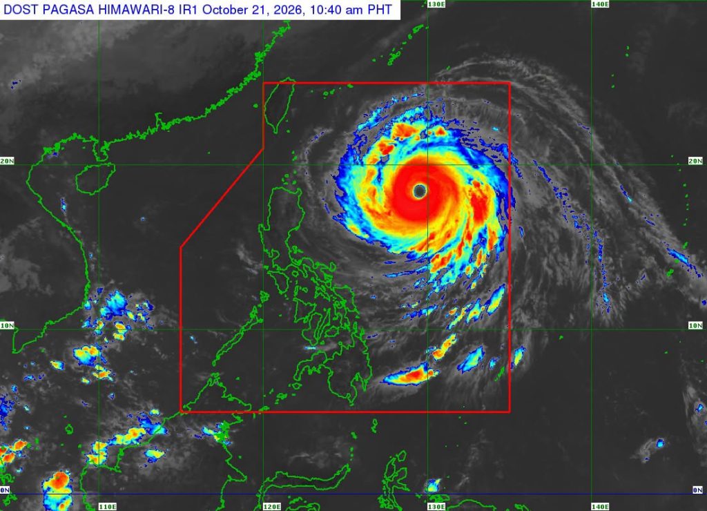
After slightly intensifying Tuesday, Super Typhoon Rosal maintained its strength and its west northwestward movement as it hovered over the Philippine Sea.
According to PAGASA’s 11:00 a.m. bulletin Wednesday, Rosal (international name: Champi) was last located 845 km east of Northern Luzon, packing maximum sustained winds of 215 kph and gustiness of up to 265 kph as it moves west northwestward at 25 kph.
Batanes was moved up to Wind Signal No. 2, with the archipelagic province expected to experience winds greater than 62 kph and up to 88 kph over the next 24 hours.
More areas have also been placed under Tropical Cyclone Wind Signal No. 1, which are expected to experience winds of 39-61 kph or intermittent rains over the next 36 hours:
- Apayao
- Babuyan Islands
- Cagayan
- Ilocos Norte
- Isabela
- Catanduanes
Meanwhile, the state weather bureau, moreover, issued a Gale Warning advisory over the following coastal waters:
- 2.8-5.5 meter-high waves over the northern and eastern seaboards of Northern Luzon (Batanes, Babuyan Islands {Babuyan Is., Camiguin Is., Calayan Is.}, the northern and eastern coasts of mainland Cagayan {Santa Ana, Gonzaga, Lal-Lo, Gattaran, Baggao, Peñablanca}, and Isabela)
- 2.8-5.0 meter-high waves over the eastern seaboard of Southern Luzon [The northern and eastern coasts of Catanduanes {Pandan, Bagamanoc, Panganiban, Viga, Gigmoto, Baras, Bato}]
- 2.8-4.5 meter-high waves over the eastern seaboards of Central Luzon, Southern Luzon and Visayas (Aurora {Dilasag, Casiguran}, Camarines Norte {Paracale, Vinzons, Talisay, Daet, Mercedes}, Camarines Sur {Siruma, Tinambac, Lagonoy, Garchitorena, Caramoan}, Albay {Rapu-Rapu}, Sorsogon {Prieto Diaz}, and Northern Samar {Laoang, Palapag, Pambujan, Mondragon, San Roque})
These areas are expected to experience strong to gale-force winds and are deemed by PAGASA to be unsafe for any form of sea travel.
Rough seas are also expected over the following coastal waters:
- • Up to 4.0 m: The eastern seaboards of northern Quezon Province and Eastern Samar; the remaining seaboard of Northern Samar.
- • Up to 3.5: The remaining seaboard of Ilocos Norte.
- • Up to 3.0 m: The seaboard of La Union; the northern seaboards of Dinagat Islands and Siargao-Bucas Grande Island Group; the remaining seaboard of Catanduanes; the northern seaboard of Ilocos Sur; the northern and eastern seaboards of Davao Oriental; the northwestern seaboard of Pangasinan.
Super Typhoon Rosal is currently at its peak intensity and is projected to continue its west-northwestward movement before turning northwestward Thursday. It will then begin to turn north northwestward by October 23, before pivoting northeastward by October 25.
jpv

