Oil spill reaches Tablas Strait, Tayabas Bay

(Photo courtesy of PhilSA)

By Gabriela Baron

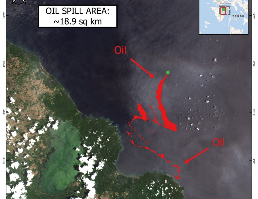
Oil spill from the sunken vessel off Naujan, Oriental Mindoro reached Tablas Strait in Oriental Mindoro, based on the latest satellite image from the Philippine Space Agency (PhilSA).

PhilSA’s satellite image taken from March 31 to April 2 showed a possible oil spill reaching Tablas Strait and Tayabas Bay in Oriental Mindoro.

Tablas Strait is a strait separating Mindoro Island from Panay and Romblon Islands, meanwhile, Tayabas Bay is bordered on the north and east side by Quezon Province.

According to PhilSA, the maps were processed from the images captured by the Copernicus European Union’s Sentinel-1 and Sentinel-2 satellites and retrieved from the International Charter Space and Major Disasters.

“The Disasters Charter is a worldwide collaboration of various space agencies and other space-related institutions through which satellite data are made available for the benefit of disaster management,” PhilSA said. – cf


Popular

PBBM orders release of P1.3 trillion budget to boost social services, disaster recovery efforts

By Dean Aubrey Caratiquet Consistent with the government’s efforts to uplift Filipinos’ lives even in the face of calamities, President Ferdinand R. Marcos Jr. directed...

PBBM orders preps for incoming storm, probe into other causes of massive floods in Visayas

By Dean Aubrey CaratiquetWith an upcoming storm set to enter the Philippine area of responsibility (PAR) within the next few days, President Ferdinand R....

OP extends P760M cash aid to 38 ‘Tino’-hit areas

By Brian Campued President Ferdinand R. Marcos Jr. has ordered the release of P760 million in cash assistance from the Office of the President (OP)...

PBBM urges gov’t offices to refrain from hosting lavish Christmas celebrations

By Dean Aubrey Caratiquet Recognizing the plight of Filipinos who have been affected by successive natural disasters across the archipelago, President Ferdinand R. Marcos Jr....