
By Dean Aubrey Caratiquet
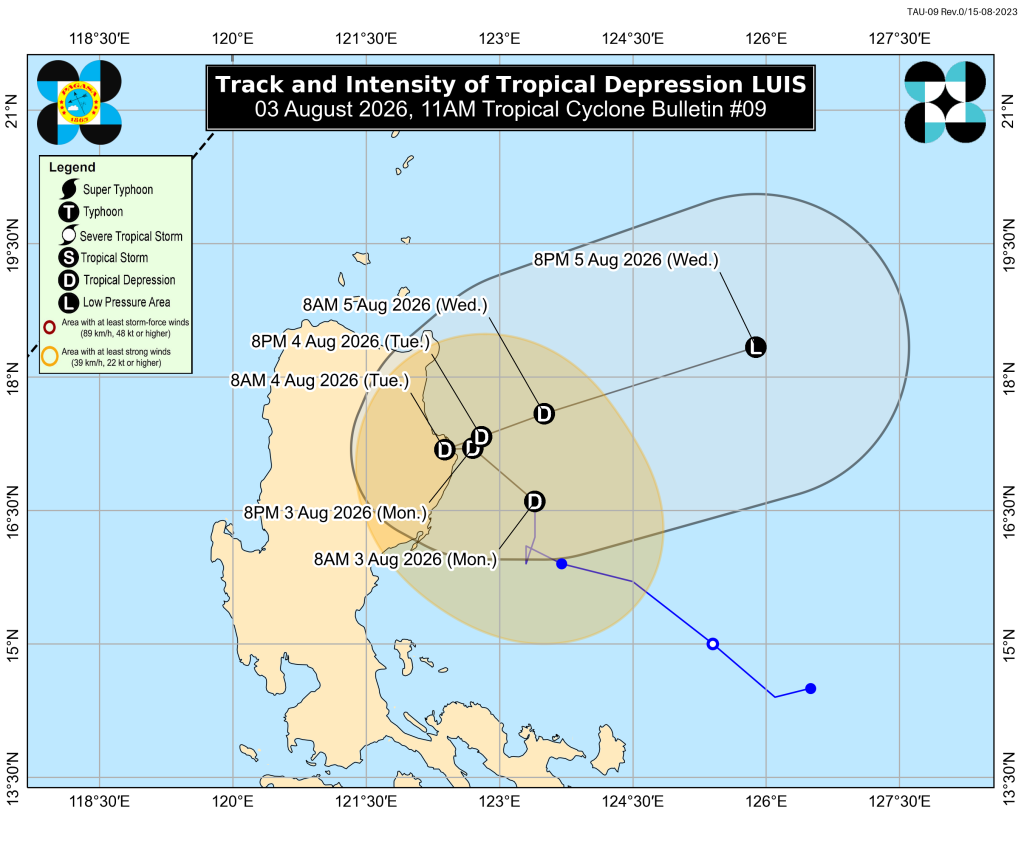
Tropical Depression Luis has slightly weakened and changed its trajectory overnight, according to PAGASA’s latest weather report.
As of 11:00 a.m. this Monday, Luis was last located 165 km east of Echague, Isabela, packing maximum sustained winds of 45 kph and gustiness of up to 55 kph as it moves northward at 15 kph.
The weather system’s proximity to Luzon has prompted the state weather bureau to hoist Tropical Cyclone Wind Signal No. 1 over Cagayan, Isabela, Quirino, Apayao, Kalinga, Mountain Province, Ifugao, and Aurora, which may experience winds of 39-61 kph or intermittent rains over the next 36 hours.
Even in the absence of a gale warning advisory, PAGASA warns owners of motorbancas and similarly sized vessels to exercise caution while venturing out to sea, with moderate seas expected over the following coastal waters:
- Up to 2.5 m: The seaboard of Isabela; the northern and eastern seaboards of Polillo Islands; the northern seaboard of Camarines Norte; the eastern seaboard of Davao Oriental; the northeastern seaboard of Aurora.
- Up to 2.0 m: The seaboards of Batanes, Cagayan including Babuyan Islands, Ilocos Norte, Ilocos Sur, La Union, Pangasinan, Zambales, Lubang Islands, and Surigao del Sur; the western seaboards of Bataan, Cavite, and Batangas; the northern seaboard of Camarines Sur; the northern and eastern seaboards of Catanduanes and Northern Samar; the eastern seaboards of Albay, Sorsogon, Eastern Samar, Dinagat Islands, Siargao-Bucas Grande Islands, and Davao Occidental; the southern seaboard of Davao Oriental.
Tropical Depression Luis is expected to move northwestward and either make landfall or pass close to northern Luzon tonight or on Tuesday (August 4), before turning east northeastward and pivoting away from the Philippine landmass.
The state weather bureau, moreover, noted a high level of uncertainty on the weather system’s forecast track, but stressed that Luis may remain as a tropical depression over the majority of the forecast period.
PAGASA, moreover, urged the public and disaster risk reduction and management offices to facilitate preparations and implement salient protocols, as well as continue monitoring further developments issued by the state weather bureau.
Meanwhile, the agency is also closely monitoring another tropical cyclone with international name “Dolphin” that was last located within the Tropical Cyclone Information Domain (TCID).
jpv

