
By Brian Campued
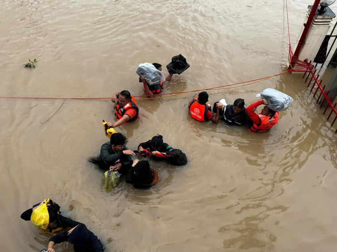
Tropical Cyclone Wind Signal (TCWS) No. 3 is still hoisted over northern and central Luzon as Severe Tropical Storm Kristine (international name: Trami) crosses the Cordillera Administrative Region (CAR) after making landfall in Divilacan, Isabela early Thursday morning, the Philippine Atmospheric, Geophysical and Astronomical Services Administration (PAGASA) said.
According to PAGASA’s tropical cyclone bulletin issued at 11:00 a.m. today, the eye of “Kristine” was last spotted in the vicinity of Bauko, Mountain Province moving westward at 20 kilometers per hour (kph).
The tropical cyclone packs maximum sustained winds of 95 kph and gustiness of up to 160 kph.
In its track forecast, the state weather bureau said Kristine may emerge over the waters west of Ilocos Region this afternoon and exit the Philippine Area of Responsibility (PAR) Friday afternoon (Oct. 25).
Due to this, parts of Northern Luzon, Cagayan Valley, and CAR are still placed under TCWS No. 3:
- Mountain Province
- Ifugao
- Benguet
- Northern portion of Nueva Vizcaya (Bayombong, Ambaguio, Bagabag, Villaverde, Kayapa, Bambang, Diadi, Quezon, Solano, Santa Fe, Aritao)
- Southern portion of Ilocos Sur (Cervantes, Quirino, Sigay, Suyo, Alilem, Sugpon, Tagudin, Santa Cruz, Salcedo, Gregorio del Pilar, San Emilio, Lidlidda, Burgos, San Esteban, Santiago, Banayoyo, Galimuyod, City of Candon, Santa Lucia, Nagbukel, Santa Maria, Narvacan)
- La Union
- Pangasinan
TCWS No. 2, likewise, is raised across most parts of Luzon:
- Cagayan including Babuyan Islands
- Isabela
- Quirino
- Rest of Nueva Vizcaya
- Apayao
- Kalinga
- Abra
- Ilocos Norte
- Rest of Ilocos Sur
- Nueva Ecija
- Aurora
- Bulacan
- Tarlac
- Pampanga
- Zambales
- Bataan
- Metro Manila
- Rizal
- Cavite
- Western portion of Batangas (Lian, Nasugbu, Tuy, Calatagan, Balayan), and the northern portion of Laguna (Cabuyao City, City of Santa Rosa, City of Bisan, City of San Pedro, Pakil, Mabitac, Pangil, Santa Maria, Siniloan, Famy)
The rest of Luzon and parts of Visayas are also under TCWS No. 1:
Luzon
- Batanes
- Rest of Batangas
- Rest of Quezon
- Rest of Occidental Mindoro
- Oriental Mindoro
- Marinduque
- Romblon
- Northern portion of mainland Palawan (El Nido, Taytay, Araceli, San Vicente, Dumaran, Roxas) including Calamian Islands, Cuyo, and, Kalayaan Islands
- Camarines Norte
- Camarines Sur
- Catanduanes
- Albay
- Sorsogon
- Masbate including Ticao and Burias Islands
Visayas
- Aklan
- Capiz
- Antique including Caluya Islands
- Iloilo
- Bantayan Islands
- Northern Samar
- Northern portion of Samar (Calbayog City, Santo Nino, Almagro, Tagapul-An, San Jorge, Matuguinao, Jiabong, Pagsanghan, City of Catbalogan, Gandara, Motiong, San Jose de Buan, Santa Margarita, Tarangnan, Daram, Zumarraga)
- Biliran
- Northern portion of Eastern Samar (Maslog, Jipapad, Arteche, Oras, San Policarpo)
- Northwestern portion of Leyte (Calubian, San Isidro)
PAGASA warns residents living in areas under the wind signals of minimal to storm-force winds brought by Kristine.
Strong to gale-force gusts are also possible in the exposed coastal and upland areas of Mimaropa, Bicol Region, the Visayas, Basilan, Sulu, Tawi-Tawi, Zamboanga del Norte, Lanao del Sur, Northern Mindanao, Dinagat Islands, Surigao del Norte, Davao del Sur, and Davao Oriental.
The agency also warned of a “minimal to moderate” threat of storm surge two meters above normal tide levels in the next 48 hours over low-lying, coastal localities of Ilocos Norte, Ilocos Sur, La Union, Pangasinan, Cagayan, Isabela, Aurora, and Zambales.
Meanwhile, the state weather bureau also cautioned against sea travel, as a gale warning is still hoisted over the seaboards of Luzon and the western and central seaboards of Visayas.
Rough to high seas, with waves up to 8.5 meters high, have been observed in the seaboards of Batanes, the northern coast of Cagayan including Babuyan Islands, Ilocos Norte, Ilocos Sur, La Union, Pangasinan, Aurora, Zambales, Bataan, Cavite, Batangas, and Lubang Islands.
Rough to very rough seas, with waves up to 6 meters high, are also expected in Isabela, the eastern coast of Cagayan, Quezon including Polillo Islands, Metro Manila, Bulacan, Occidental Mindoro, and Palawan including Calamian, Cuyo, Cagayancillo, and Kalayaan Islands.
Rough to very rough seas, with waves up to 4.5 meters high, will persist over Camarines Norte, Camarines Sur, Catanduanes, Oriental Mindoro, Marinduque, Romblon, Burias Island, the southwestern coast of Negros Oriental, Negros Occidental, Guimaras, Iloilo, Capiz, Aklan, and Antique.
“All mariners must remain in port or, if underway, seek shelter or safe harbor as soon as possible until winds and waves subside,” the state weather bureau said.
In terms of rainfall, PAGASA said that intense to torrential rains are expected in Pangasinan, Zambales, La Union, and Occidental Mindoro until Friday noon.
Heavy to intense rains will also persist over Cagayan Valley, CAR, the rest of Ilocos Region, Tarlac, Pampanga, Bataan, Cavite, Batangas, and Calamian Islands.
Moderate to heavy rains will be experienced in Metro Manila, Bulacan, Nueva Ecija, Aurora, Laguna, Rizal, Quezon, Oriental Mindoro, Marinduque, Romblon, Antique, Aklan, Negros Occidental, and Palawan.
Meanwhile, PAGASA is also monitoring a low pressure area (LPA) outside the PAR that has a “high chance” of developing into a tropical depression within the next 24 hours.
As of 10:00 a.m., the LPA was located 2,295 km east of northeastern Mindanao.
—iro