
By Brian Campued
The state weather bureau has raised Tropical Cyclone Wind Signal (TCWS) No. 1 over the eastern section of the country as Severe Tropical Storm Uwan (international name Fung-Wong) slightly intensified while still outside the Philippine area of responsibility (PAR) on Friday.
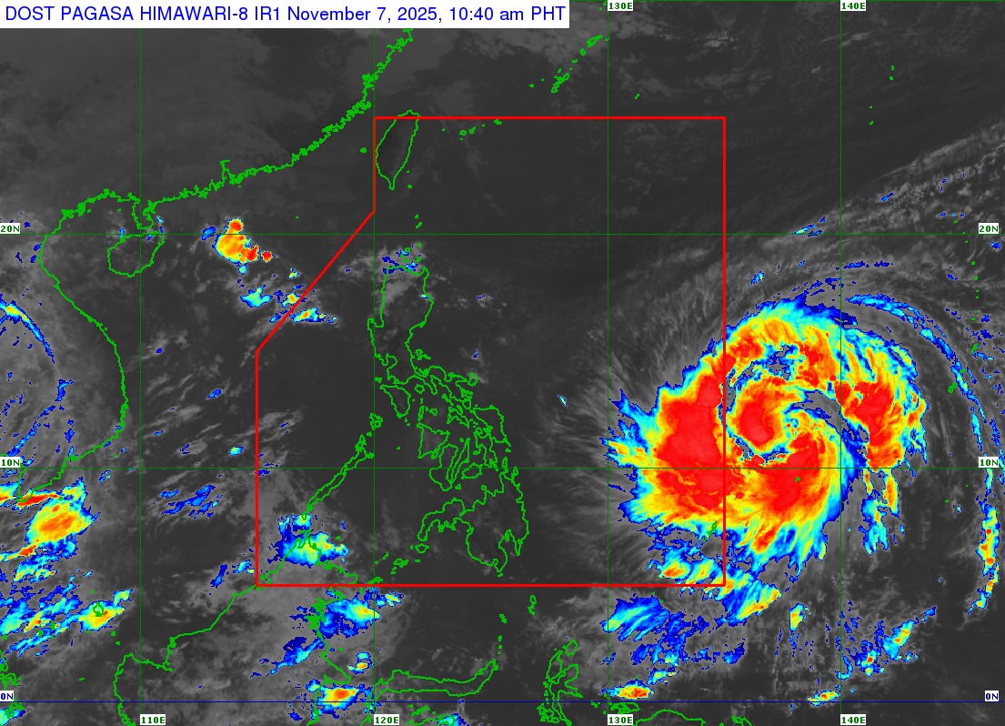
As of 4:00 p.m., Uwan was located 1,175 km east of Eastern Visayas with maximum sustained winds of 110 kph near its center and gustiness of up to 135 kph.
The storm is moving rapidly westward at 25 kph and may enter the PAR late Friday evening or early Saturday morning (Nov. 8).
In anticipation of the wind threat of Uwan, Wind Signal No. 1 is hoisted in the following areas:
- Southeastern portion of Quezon (Tagkawayan, Guinayangan, Calauag, Lopez, Buenavista, Catanauan, Mulanay, San Narciso, San Andres, San Francisco)
- Eastern portion of Romblon (Cajidiocan, San Fernando, Magdiwang)
- Camarines Norte
- Camarines Sur
- Catanduanes
- Albay
- Sorsogon
- Masbate
- Northern Samar
- Eastern Samar
- Samar
- Biliran
- Leyte
- Southern Leyte
- Northern and central portions of Cebu (Medellin, Daanbantayan, City of Bogo, Tabogon, San Remigio, Tabuelan, Borbon, Sogod, Tuburan, Catmon, Carmen, Danao City, Compostela, Liloan, Consolacion, Lapu-Lapu City, Mandaue City, Cordova, Asturias, Cebu City, Balamban, City of Talisay, Toledo City, Minglanilla), including Bantayan and Camotes Islands
- Northeastern portion of Bohol (Getafe, Talibon, Buenavista, Trinidad, San Miguel, Ubay, Alicia, Mabini, Bien Unido, Pres. Carlos P. Garcia)
- Northern portion of Negros Occidental (City of Escalante, Toboso, Sagay City, Cadiz City, Calatrava, Manapla)
- Northeastern portion of Capiz (President Roxas, Pilar, Panay, Pontevedra)
- Northeastern portion of Iloilo (Carles, Estancia, Balasan, San Dionisio, Concepcion, Batad, Sara, Ajuy)
- Dinagat Islands
- Surigao del Norte
Areas under TCWS No. 1 may experience strong winds within 36 hours.
The Philippine Atmospheric, Geophysical and Astronomical Services Administration (PAGASA) said the highest possible wind signal that may be raised during Uwan’s passage is Wind Signal No. 5.
PAGASA Assistant Weather Services Chief Engr. Chris Perez said that Uwan may intensify into a typhoon on Saturday morning near Eastern Visayas and reach super typhoon category on Sunday while over the sea east of Virac, Catanduanes.
“Pagdating ng 36 hours, posible na pong maramdaman ang epekto nito sa ilang bahagi ng Luzon at ng Visayas,” Perez said in a public briefing, noting that Uwan may make landfall over the Isabela-Aurora area between late Sunday evening to early Monday morning.
Due to the area of probability in the forecast track, Perez said that Uwan may also make early landfall over the Bicol Region, Quezon Province, or Isabela-Tuguegarao (Cagayan) area—emphasizing that provinces on the eastern section of Luzon must also prepare for possible landfall scenarios.
Aside from winds, Uwan will likely drench most parts of Luzon—with intense to torrential rains expected over Camarines Sur, Catanduanes, and Albay from Saturday to Sunday afternoon (Nov. 9).
Heavy to intense rains are forecast over Cagayan, Isabela, Quirino, Aurora, Quezon, Camarines Norte, Sorsogon, Masbate, Northern Samar, Samar, and Eastern Samar during the period; while moderate to heavy rains will persist over Apayao, Kalinga, Mountain Province, Ifugao, Nueva Vizcaya, Nueva Ecija, Bulacan, Rizal, Laguna, Marinduque, Romblon, Biliran, and Leyte.
By Sunday afternoon until Monday (Nov. 10), Uwan will dump up to torrential rains over Aurora, Nueva Ecija, Cagayan, Isabela, Quirino, Nueva Vizcaya, Apayao, Kalinga, Abra, Mountain Province, Ifugao, Benguet, Ilocos Norte, Ilocos Sur, La Union, and Pangasinan.
Metro Manila, Zambales, Bataan, Tarlac, Pampanga, Bulacan, Cavite, Laguna, Batangas, Rizal, Quezon, and Occidental Mindoro will experience up to intense rains, while up to heavy rains will drench Batanes, Oriental Mindoro, Marinduque, Romblon, Camarines Norte, Camarines Sur, Aklan, and Antique.
Residents in high-risk areas are warned of flooding and landslides due to heavy rains. According to the Department of Environment and Natural Resources – Mines and Geosciences Bureau, about 8,164 barangays across the country are susceptible to rain-induced flooding and landslides.
Life-threatening storm surge and coastal flooding are also expected over parts of northern Luzon and along the east coast of central and southern Luzon. PAGASA said storm surge warnings may be issued Friday night or Saturday.
A gale warning will likewise be issued for the eastern seaboards of Luzon, Visayas, and the Caraga Region in anticipation of very rough to worse sea conditions. Mariners are strongly urged to avoid sea travel.
-av