
By Brian Campued
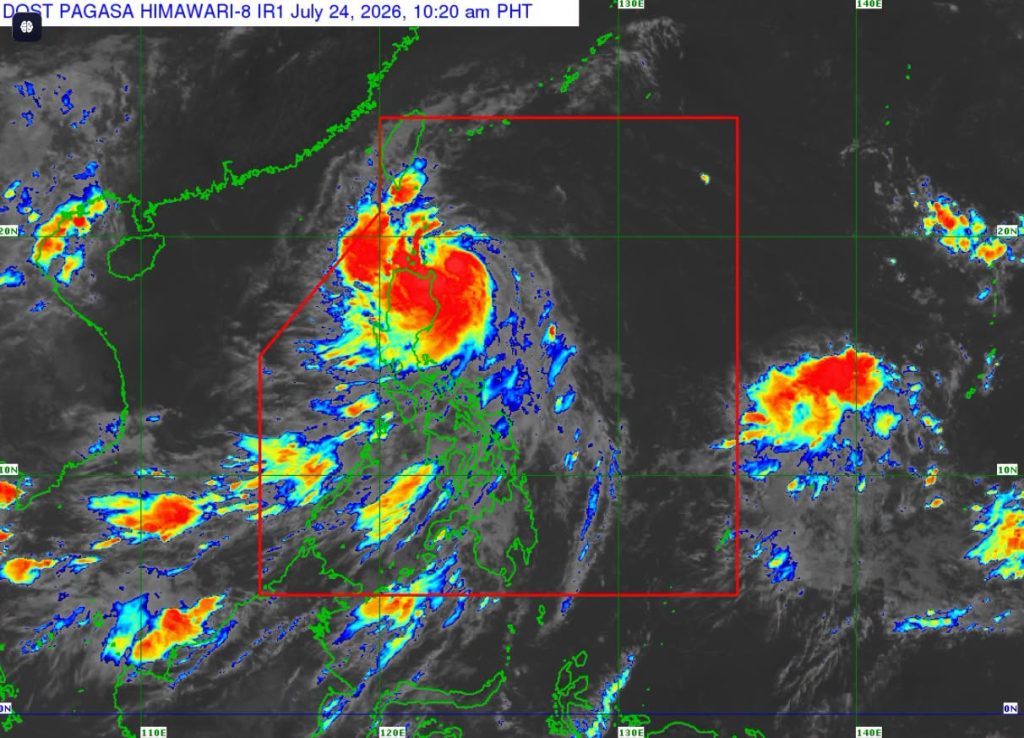
Parts of Ilocos Region and Cagayan Valley have been placed under Tropical Cyclone Wind Signal (TCWS) No. 2 as Tropical Storm Kiyapo (international name: Noul) slightly intensifies while moving near extreme northern Luzon on Friday.
In its 11:00 a.m. bulletin, the Philippine Atmospheric, Geophysical and Astronomical Services Administration (PAGASA) said “Kiyapo,” which intensified into a tropical storm at 2:00 a.m., was last located 135 km east of Aparri, Cagayan.
Kiyapo currently packs maximum sustained winds of 75 kph near its center and gustiness of up to 90 kph. It is moving westward at 30 kph.
“Mapapansin natin na papalapit na nang papalapit itong si Bagyong Kiyapo sa Babuyan Islands,” PAGASA Weather Specialist John Manalo said in a live briefing, adding that Kiyapo may further intensify into a severe tropical storm by Friday evening after passing the Babuyan Islands.
Based on the track forecast, PAGASA said Kiyapo may pass very close or make landfall in the vicinity of Babuyan Islands between Friday afternoon and evening.
PAGASA warned residents in areas under TCWS No. 2 to brace for gale-force winds (62-88 kph) within the next 24 hours, as it may pose minor to moderate threat to life and property:
- Batanes
- Northern portion of Cagayan (Santa Ana, Gonzaga, Santa Teresita, Camalaniugan, Aparri, Ballesteros, Abulug, Pamplona, Sanchez-Mira, Claveria, Santa Praxedes, Buguey, Allacapan, Lal-Lo, Gattaran, Baggao, and Lasam) including Babuyan Islands
- Northern portion of Apayao (Luna, Santa Marcela, Calanasan, Pudtol, and Flora)
- Northern portion of Ilocos Norte (Pagudpud, Dumalneg, Adams, Bangui, Burgos, and Vintar)
Kiyapo may also bring strong winds (39-61 kph) that may cause minimal to minor impacts within the next 36 hours in areas under Wind Signal No. 1:
- Rest of mainland Cagayan
- Isabela
- Quirino
- Nueva Vizcaya
- Rest of Apayao
- Abra
- Kalinga
- Mountain Province
- Ifugao
- Benguet
- Rest of Ilocos Norte
- Ilocos Sur
- La Union
- Northern and central portions of Aurora (Dilasag, Casiguran, Dinalungan, and Dipaculao)
Meanwhile, most of the country, especially in coastal and upland areas exposed to winds, will experience strong to gale-force gusts this Friday due to the combined effects of the southwest monsoon (habagat) and the periphery of Tropical Storm Kiyapo.
Heavy rains
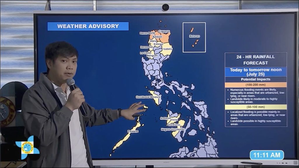
Kiyapo is also forecast to bring intense to torrential rains (100-200 mm) until Saturday noon (July 25) over Batanes, Cagayan, Apayao, and Ilocos Norte, and moderate to heavy rains (50-100 mm) in Isabela, Kalinga, Abra, Benguet, Ilocos Sur, and La Union.
Habagat, on the other hand, will bring moderate to heavy rains over Occidental Mindoro, Palawan, Antique, Iloilo, Guimaras, and Negros Occidental until Saturday noon.
Residents in the abovementioned areas are advised to remain vigilant for flooding and landslides.
According to the Mines and Geosciences Bureau (MGB) of the Department of Environment and Natural Resources (DENR), a total of 3,579 barangays nationwide are susceptible to rain-induced landslides and flooding over the weekend.
In the Ilocos Region alone, the DENR-MGB identified at least 756 barangays that are prone to rain hazards, followed by Cagayan Valley (569) and Cordillera Administrative Region (354).
Residents in listed areas as well as those nearby or downstream are urged to remain vigilant and take necessary precautions.
Gale warning
Meanwhile, PAGASA warned against sea travel as strong to gale-force winds associated with Tropical Storm Kiyapo are expected to cause rough to very rough sea conditions along the seaboards of northern Luzon.
Waves of up to 5.5 meters may be experienced in the northern seaboards of Batanes and Babuyan Islands, while up to 4.5 meters are possible over the northern seaboards of Cagayan and Ilocos Norte.
Mariners of small seacrafts, including motor bancas, are advised to remain in port or seek safe harbor. Larger vessels may continue operating in stormy conditions, provided that personnel are properly trained and equipped to ensure safety while at sea.
“Huwag muna tayo pumalaot, lalo na kung maliit na sasakyang-pandagat yung ating gagamitin,” Manalo said.
According to PAGASA, Kiyapo may exit the Philippine area of responsibility (PAR) by Saturday morning.
-jpv

