By Dean Aubrey Caratiquet
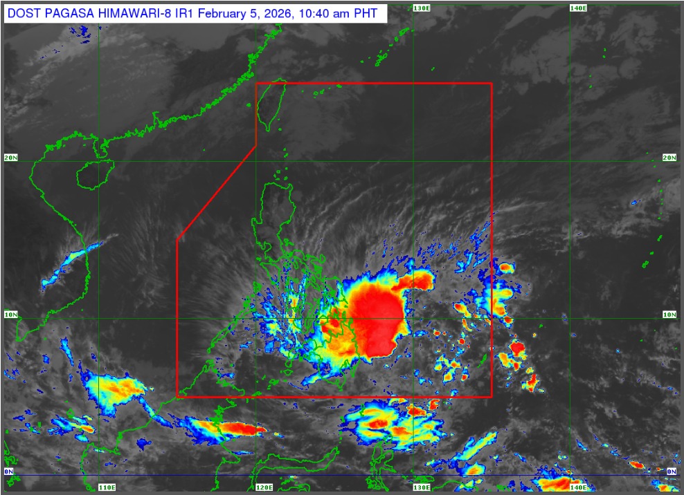
Tropical Storm Basyang increased its speed and strength as it continues to hover over waters east of Mindanao, according to PAGASA’s 11:00 a.m. bulletin.
Basyang (international name: Penha) was last located 295 km east of Hinatuan, Surigao del Sur, packing maximum sustained winds of 65 kph near the center and gustiness of up to 80 kph as it moves westward at 25 kph.
As the tropical cyclone nears the Philippine landmass, Philippine Atmospheric, Geophysical, and Astronomical Services Administration (PAGASA) has hoisted Tropical Cyclone Wind Signal (TCWS) No. 2 in Siquijor, Negros Oriental Cebu, Bohol, Surigao del Norte (including Siargao and Bucas Grande Islands), Surigao del Sur, Davao Oriental, Bukidnon, Lanao del Norte, Misamis Occidental and Camiguin, which may experience between 62-88 kph winds in the next 24 hours.
Signal No. 1 prevails over the following areas, which are expected to experience between 39-61 kph winds over the next 36 hours:
- Cagayancillo and Cuyo Islands
- Eastern Samar
- Samar
- Leyte
- Southern Leyte
- Bohol
- Cebu
- Negros Oriental
- Negros Occidental
- Guimaras
- Iloilo
- Capiz
- Aklan
- Antique
- Dinagat Islands
- Davao Oriental
- Davao de Oro
- Davao del Norte
- Davao del Sur
- Bukidnon
- Cotabato
- Lanao del Sur
- Maguindanao del Norte
- Lanao del Norte
- Misamis Occidental
- Zamboanga del Norte
- Zamboanga del Sur
- Zamboanga Sibugay
The state weather bureau likewise noted a minimal to moderate storm surge risk over the coastal areas of Agusan del Norte, Antique, Bohol, Camiguin, Cebu, Davao Oriental, Dinagat Islands, Iloilo, Leyte, Misamis Oriental, Negros Occidental, Negros Oriental, Palawan, Siquijor, Southern Leyte, Surigao del Norte, and Surigao del Sur.
With a gale warning in effect, PAGASA also advises owners of small vessels and fisherfolk against sailing over the eastern seaboards of Visayas, as well as the eastern and northern seaboards of Mindanao, respectively, with rough to very rough seas generating between 2.8-5.0 meter high waves.
After beginning to move westward, Basyang is expected to gain strength before its initial landfall over Surigao del Sur on Thursday night, before turning west northwestward on Friday (Feb. 6) as it crosses Mindanao and emerges over Bohol Sea.est northwestward on Friday (Feb. 6) as it crosses Mindanao and emerges over Bohol Sea.
jpv