
By Ma. Cristina Arayata | Philippine News Agency
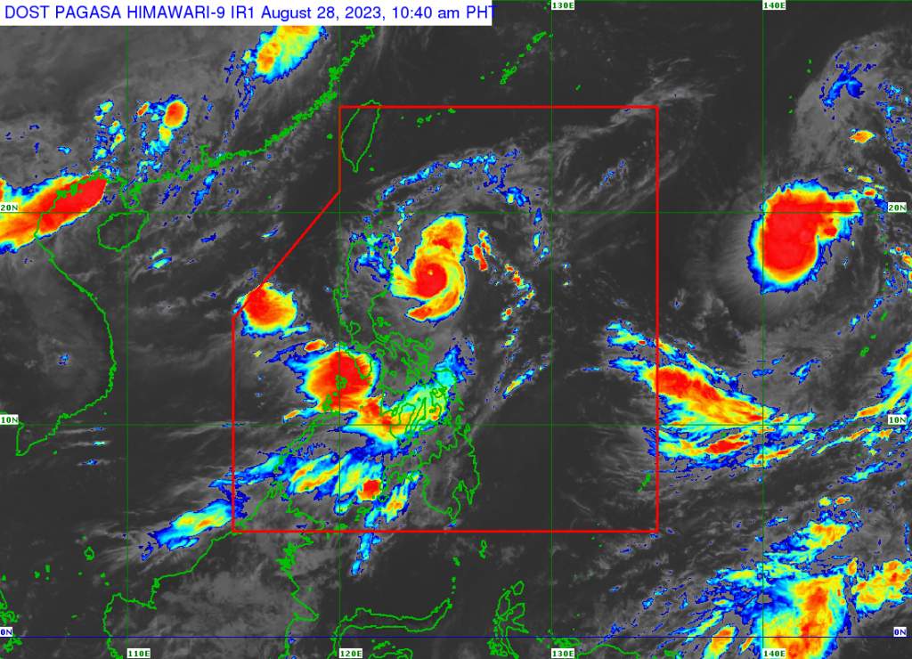
Goring has weakened into a typhoon but a new tropical cyclone is likely to enter this week, the weather bureau said Monday.
The typhoon now packs 175 kilometers per hour (kph) near the center and gustiness of up to 215 kph.
It was last tracked 210 kilometers east of Casiguran, Aurora, the Philippine Atmospheric, Geophysical and Astronomical Services Administration (PAGASA) said in its 5:00 a.m. weather bulletin.
Tropical Cyclone Wind Signal (TCWS) No. 1 has remained hoisted over Batanes, Babuyan Islands, the northern and eastern portions of mainland Cagayan (Camalaniugan, Pamplona, Gonzaga, Santa Teresita, Baggao, Buguey, Santa Ana, Claveria, Aparri, Ballesteros, Abulug, Sanchez-Mira, Santa Praxedes, Allacapan, Lal-Lo, Lasam, Peñablanca, Iguig, Amulung, Gattaran, Alcala), the eastern portion of Isabela (Dinapigue, San Mariano, San Guillermo, Ilagan City, Tumauini, San Pablo, Cabagan, Maconacon, Divilacan, Palanan), the northern and central portions of Aurora (Casiguran, Dinalungan, Dilasag, Baler, Dipaculao, Maria Aurora, San Luis), Polillo Islands, the northern and eastern portions of Camarines Norte (Capalonga, Jose Panganiban, Paracale, Vinzons, Talisay, Daet, Mercedes) including Calaguas Islands, the northeastern portion of Camarines Sur (Siruma, Tinambac, Lagonoy, Garchitorena, Caramoan) and the northern portion of Catanduanes (Panganiban, Caramoran, Viga, Bagamanoc, Pandan).
“Local winds may be slightly stronger/enhanced in coastal and upland/mountainous areas exposed to winds. Winds are less strong in areas sheltered from the prevailing wind direction,” PAGASA said.
The southwest monsoon enhanced by Goring will bring occasional or monsoon rains over the western portions of Central and Southern Luzon and the Visayas over the next three days.
It will also continue to cause gusty conditions over the following areas not under signal No. 1, especially in coastal and upland/mountainous areas: the Visayas, Aurora, Bataan, Metro Manila, Calabarzon, Mimaropa, Bicol Region, Dinagat Islands, Camiguin, and most of Zamboanga Peninsula.
Rough to very rough seas are forecast over the northern and eastern seaboards of Northern Luzon, the eastern seaboards of Central Luzon, the seaboards of Southern Luzon, and the western seaboard of the Visayas.
“Disruption in civilian maritime activities is expected over these areas due to hazardous sea conditions,” PAGASA said.
Meanwhile, a tropical cyclone was tracked 2,290 km east of Northern Luzon, outside the Philippine area of responsibility.
There is a high chance that this tropical cyclone will enter, PAGASA said. – gb

