
By Alec Go
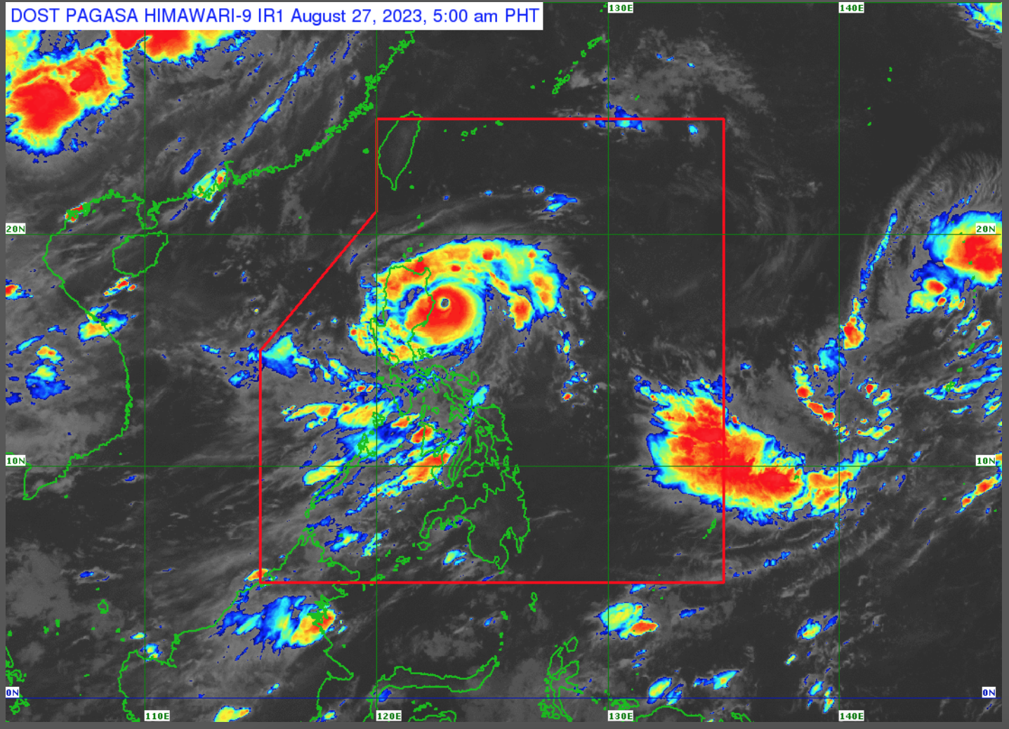
“Goring” has intensified into a super typhoon over the coastal waters of Palanan, Isabela, the Philippine Atmospheric, Geophysical and Astronomical Services Administration (PAGASA) said Sunday morning, Aug. 27.
As of 4:00 a.m, Super Typhoon “Goring” is slowly moving south southwestward with maximum sustained winds of 185 kilometers per hour (km/h) near the center and gustiness of up to 230 km/h.
Tropical Cyclone Wind Signals (TCWS) are hoisted over the following areas as of 5:00 a.m.:
TCWS No. 3
Extreme eastern portion of Isabela (Divilacan, Palanan)
TCWS No. 2
- Eastern portion of mainland Cagayan (Peñablanca, Baggao, Gattaran, Lal-Lo, Gonzaga, Santa Teresita, Buguey, Santa Ana)
- Eastern portion of Isabela (Dinapigue, Ilagan City, Maconacon, Cabagan, Tumauini, San Pablo, Benito Soliven, San Mariano)
Extreme northern portion of Aurora (Dilasag, Casiguran)
TCWS No. 1
- Babuyan Islands
- Rest of mainland Cagayan
- Rest of Isabela
- Quirino
- Nueva Vizcaya
- Apayao
- Kalinga
- Abra
- Mountain Province
- Ifugao
- Eastern portion of Benguet (Bokod, Buguias, Kabayan, Mankayan)
- Eastern portion of Ilocos Norte (Pagudpud, Adams, Vintar, Carasi, Nueva Era, Banna, Marcos, Dingras, Solsona, Piddig, Dumalneg, Bangui)
- Northeastern portion of Nueva Ecija (Carranglan, Pantabangan, Bongabon, Gabaldon, Laur, Rizal)
- Northern and central portions of Aurora (Dinalungan, Dipaculao, Baler, Maria Aurora, San Luis)
- Polillo Islands
- Calaguas Islands
The super typhoon will continue to bring stormy weather conditions over the eastern portion of Cagayan and Isabela this Sunday.
These may result in flooding or landslides due to heavy to intense rains, and may pose “moderate to significant threat to lives and properties due to strong winds.”
“Goring” will also bring rains with gusty winds over Ilocos Norte, the Cordillera Administrative Region, Aurora, Nueva Ecija, and the rest of Cagayan Valley, which may trigger flooding and landslides.
The trough of “Goring” will bring cloudy skies with scattered to widespread rains and thunderstorms over the rest of Ilocos Region.
Meanwhile, occasional rains will prevail over Zambales, Bataan, Occidental Mindoro, and northern Palawan due to enhanced southwest monsoon or habagat.
Habagat will also cause cloudy skies with scattered rain showers and thunderstorms over Metro Manila, the rest of Luzon, and Western Visayas.
The rest of the country will have partly cloudy to cloudy skies with isolated rain showers or thunderstorms due to habagat or localized thunderstorms.
A Gale warning is in effect over the northern and eastern coastal waters of Luzon.
PAGASA said GORING may begin its loop over the Philippine Sea east of Cagayan-Isabela area on Sunday, and will move in a northward direction on Monday and northwestward on Tuesday.
It is forecast to remain a super typhoon until it makes landfall over the southern portion of Taiwan late Wednesday or early Thursday, and may exit the Philippine Area of Responsibility (PAR) as a minimal typhoon.
Meanwhile, another low pressure area was spotted outside PAR at 1,960 km east northeast of Eastern Visayas. Enhancement to a tropical depression was not ruled out.