
By Brian Campued
The possibility of hoisting the highest Tropical Cyclone Wind Signal (TCWS) No. 5 is not being ruled out by the state weather bureau as Typhoon Julian continues to intensify this Monday morning.
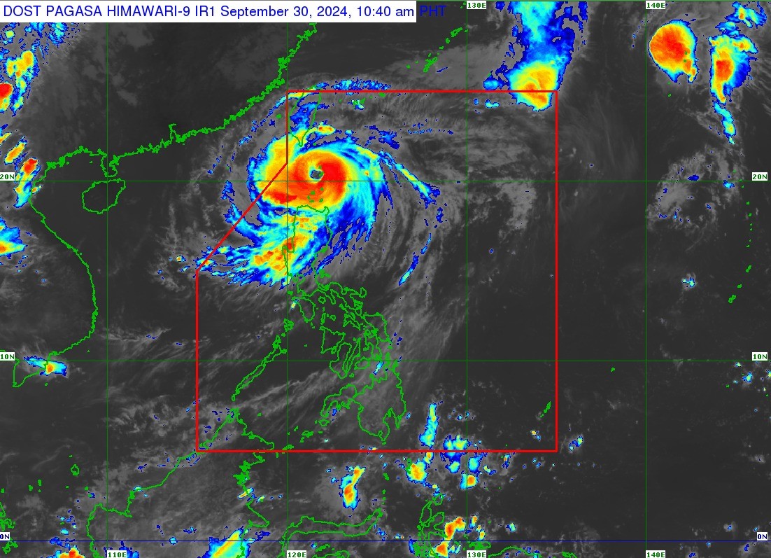
In its 11:00 a.m. tropical cyclone bulletin, the Philippine Atmospheric, Geophysical and Astronomical Services Administration (PAGASA) said Julian packs maximum sustained winds of 175 kilometers per hour (kph) near its center and gustiness of up to 215 kph.
The eye of the storm was last located over the coastal waters of Sabtang Island in Batanes, moving north-northwestward at 10 kph.
According to PAGASA, Julian may reach super typhoon category on Monday afternoon or evening. Under the state weather bureau’s classification, a super typhoon has maximum sustained winds exceeding 185 kph.
In its track forecast, PAGASA said Julian is forecast to move generally west-northwestward over the Bashi Channel on Monday and will begin recurving Tuesday until it makes landfall in Taiwan on Wednesday.
“After 24 hours, ito ay nasa may laying 200 km west ng Itbayat, Batanes, and then after 48 hours, nasa 240 km na ito northwest ng Itbayat, Batanes, and then 390 km north of Itbayat, Batanes after 72 hours,” PAGASA weather specialist Veronica Torres said in a press briefing.
TCWS Nos. 4 to 1 are currently raised in the following areas:
Signal No. 4
- Batanes
- Northern portion of Babuyan Islands (Babuyan Island, Calayan Island)
Signal No. 3
- Rest of Babuyan Islands
- Northeastern portion of mainland Cagayan (Santa Ana)
Signal No. 2
- Rest of mainland Cagayan
- Apayao
- Abra
- Kalinga
- Ilocos Norte
- Northern and central portions of Ilocos Sur (Sinait, Cabugao)
Signal No. 1
- Rest of Ilocos Sur
- La Union
- Pangasinan
- Ifugao
- Mountain Province
- Benguet
- Isabela
- Nueva Vizcaya
- Quirino
- Aurora
- Northern and eastern portions of Nueva Ecija (Cuyapo, Rizal, Laur, Pantabangan, Science City of Muñoz, Gabaldon, Carranglan, San Jose City, Lupao, Talugtug, Bongabon, Llanera, Talavera, Palayan City, General Mamerto Natividad)
- Polillo Islands
“The peak of devastating typhoon-force winds will be felt over areas under Wind Signal No. 4 between this morning and afternoon,” PAGASA warned, stressing that there is general wind threat over the areas under wind signals.
The wind flow coming towards the circulation of Julian may also bring strong to gale-force gusts today over Aurora, Zambales, Bataan, Metro Manila, Calabarzon, Romblon, and Bicol, particularly in coastal and upland areas exposed to winds.
PAGASA also warned of “moderate to high risk” threat of storm surge in the next 48 hours over low-lying, coastal localities of Batanes, Cagayan, and Ilocos Norte.
Meanwhile, the agency also cautioned against sea travel as a gale warning is hoisted over the seaboards of Northern Luzon.
Very high seas are seen in the seaboards of Batanes (waves up to 14 meters high) and Babuyan Islands (waves up to 10 meters high), which are risky for all vessels.
Very rough seas will persist in the northern seaboard of Ilocos Norte (waves up to 6 meters high) as well as the northern seaboard of mainland Cagayan and the remaining seaboard of Ilocos Norte (waves up to 5 meters high). Travel is risky for most types of vessels.
Small vessels are advised not to venture out to sea as moderate or rough seas are also expected over the remaining seaboard of Cagayan and seaboard of Ilocos Sur (waves up to 4 meters) high; seaboard of Isabela (waves up to 3.5 meters); seaboard of the northern portion of Aurora and the remaining seaboard of Ilocos Region (waves up to 3 meters high); and the remaining seaboard of Aurora as well as the northern and eastern seaboard of Polillo Islands (waves up to 2.5 meters high).
In terms of rainfall, Torres said intense to torrential rains are expected in Batanes, Babuyan Islands, and Ilocos Norte until Tuesday noon; heavy to intense rains over mainland Cagayan, Ilocos Sur, La Union, Apayao, Benguet, and Abra; and moderate to heavy rains in Pangasinan, Zambales, Bataan, and the rest of the Cordillera Administrative Region. —avds