
By Brian Campued
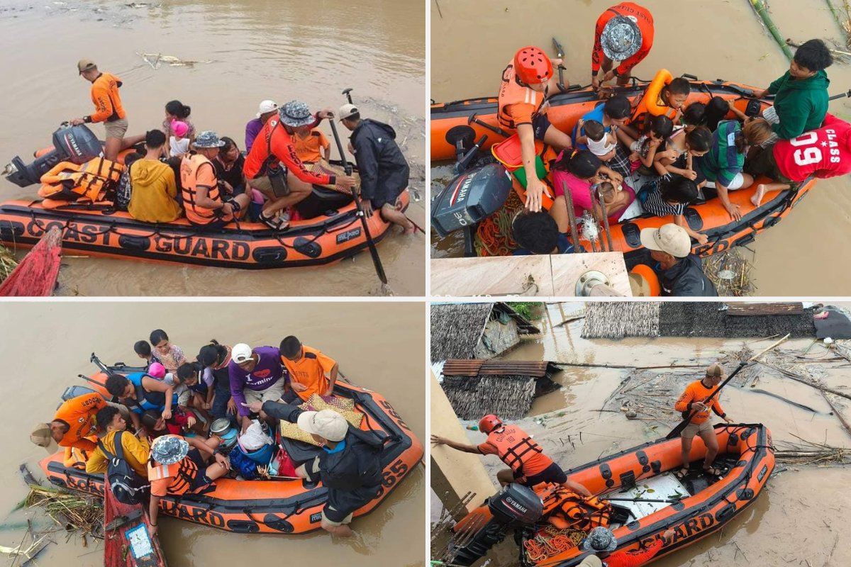
Tropical cyclone Kristine has intensified into a severe tropical storm over the Philippine Sea before its forecast landfall over Isabela province late Wednesday evening or early Thursday morning, PAGASA reported.
According to PAGASA’s tropical cyclone bulletin issued at 5:00 p.m., the eye of Severe Tropical Storm Kristine was located 175 kilometers (km) east of Echague, Isabela, while moving northwestward at 20 kilometers per hour (kph).
Kristine now packs maximum sustained winds of 95 kph and gustiness of up to 115 kph.
The state weather bureau said the storm may exit the Philippine area of responsibility on Friday (Oct. 25).
Due to this, Tropical Cyclone Wind Signal (TCWS) No. 3 has been raised over the following areas in Luzon:
- Isabela
- Kalinga
- Mountain Province
- Ifugao
- Central portion of Abra (Malibcong, Licuan-Baay, Sallapadan, Daguioman, Bucloc, Boliney, Tubo, Luba, Manabo, Bucay, Villaviciosa, Pilar, San Isidro, Pe)
- Benguet
- Quirino
- Nueva Vizcaya
- Northern and central portions of Aurora (Dilasag, Casiguran, Dinalungan, Dipaculao, Maria Aurora, Baler)
- Northern portion of Nueva Ecija (Carranglan, Lupao, San Jose City, Pantabangan)
- Pangasinan
- La Union
- Central and southern portions of Ilocos Sur (Cervantes, Quirino, Sigay, Suyo, Alilem, Sugpon, Tagudin, Santa Cruz, Salcedo, Gregorio del Pilar, San Emilio, Lidlidda, Burgos, San Esteban, Santiago, Banayoyo, Galimuyod, City of Candon, Santa Lucia, Nagbukel, Santa Maria, Narvacan)
TCWS No. 2 is, likewise, hoisted in the following areas in Luzon:
- Ilocos Norte
- Rest of Ilocos Sur
- Apayao
- Rest of Abra
- Cagayan, including Babuyan Islands
- Rest of Aurora
- Rest of Nueva Ecija
- Bulacan
- Tarlac
- Pampanga
- Zambales
- Bataan
- Metro Manila
- Cavite
- Laguna
- Rizal
- Quezon, including Polillo Islands
- Camarines Norte
- Camarines Sur
- Catanduanes
Several areas across Luzon, Visayas, and Mindanao are also under TCWS No. 1:
Luzon
- Batanes
- Batangas
- Occidental Mindoro including Lubang Islands
- Oriental Mindoro
- Marinduque
- Romblon
- Calamian Islands
- Albay
- Sorsogon
- Masbate, including Ticao and Burias Islands
Visayas
- Aklan
- Capiz
- Antique, including Caluya Islands
- Iloilo
- Guimaras
- Northern portion of Negros Occidental (Pontevedra, La Castellana, Moises Padilla, Bago City, La Carlota City, Valladolid, Pulupandan, Bacolod City, San Enrique, Murcia, Silay City, City of Talisay, Enrique B. Magalona, Manapla, City of Victorias, Cadiz City, Sagay City, City of Escalante, Toboso, Calatrava, Salvador Benedicto, San Carlos City)
- Northern portion of Negros Oriental (Vallehermoso, Canlaon City, City of Guihulngan)
- Northern and central portions of Cebu (Alcantara, Argao, Dumanjug, Sibonga, Pinamungahan, Ronda, Liloan, Cebu City, Moalboal, Consolacion, Danao City, Borbon, Carmen, Daanbantayan, Tuburan, City of Bogo, Tabogon, City of Naga, Lapu-Lapu City, City of Carcar, Mandaue City, Catmon, Minglanilla, Toledo City, Cordova, Compostela, San Remigio, Balamban, Aloguinsan, San Fernando, Asturias, Barili, Medellin, Sogod, Tabuelan, City of Talisay) including Bantayan Islands and Camotes Islands
- Bohol
- Eastern Samar
- Northern Samar
- Samar
- Leyte
- Biliran
- Southern Leyte
Mindanao
- Dinagat Island
- Surigao del Norte, including Siargao, Bucas Grande Group
PAGASA also warned of a “moderate to high risk” threat of storm surge in the next 48 hours over low-lying, coastal localities of Aurora, Cagayan, Isabela, and Quezon (between 2.1-3 meters in height) and Cagayan, Ilocos Norte, Ilocos Sur, La Union, Pangasinan, and Zambales (between 1-2 meters in height).
Meanwhile, the agency also cautioned against sea travel as a gale warning is hoisted over the seaboards of Luzon and Visayas.
Rough to high seas, with waves up to 8.5 meters high, are seen in the seaboard of Batanes, Cagayan, including the Babuyan Islands, Isabela, Ilocos Norte, Ilocos Sur, La Union, Pangasinan, Aurora, Zambales, and Bataan.
Rough to high seas, with waves up to 6 meters high, are also expected over Quezon, including Polillo Islands, Camarines Norte, Camarines Sur, Catanduanes, Metro Manila, Bulacan, Cavite, Batangas, Occidental Mindoro, including Lubang Islands, and Calamian Islands.
Rough to very rough seas, with waves up to 4.5 meters high, will persist over Albay, Sorsogon, Oriental Mindoro, Marinduque, Romblon, Masbate, including Burias And Ticao Islands, Samar, Eastern Samar, Northern Samar, Biliran, Leyte, Negros Oriental, Negros Occidental, Guimaras, Iloilo, Capiz, Aklan, Antique, Bohol, and Cebu.
“All mariners must remain in port or, if underway, seek shelter or safe harbor as soon as possible until winds and waves subside,” the state weather bureau said.
In terms of rainfall, PAGASA said that intense to torrential rains are expected today in Cagayan, Isabela, Apayao, Aurora, and Quezon; and heavy to intense rains over the rest of Cagayan Valley, the rest of Cordillera Administrative Region, Ilocos Region, the rest of Central Luzon, Rizal, and Camarines Norte.
Moderate to heavy rains will also persist over the rest of Calabarzon, Metro Manila, Occidental Mindoro, Oriental Mindoro, Marinduque, Romblon, Calamian Islands, Camarines Sur, Catanduanes, Albay, Sorsogon, Masbate, and Western Visayas.
—av