
By Brian Campued
Tropical Storm Kristine is forecast to intensify into a severe tropical storm before making landfall over Isabela on Wednesday evening, according to the state weather bureau.
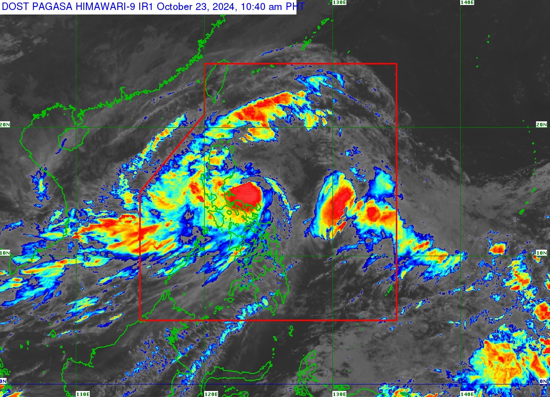
In its tropical cyclone bulletin issued at 11:00 a.m., the Philippine Atmospheric, Geophysical and Astronomical Services Administration (PAGASA) said “Kristine” was located 255 km east of Baler, Aurora, while moving north-northwestward at 30 kilometers per hour (kph).
The tropical storm packs maximum sustained winds of 85 kph near its center and gustiness of up to 105 kph.
In a public briefing, PAGASA Assistant Weather Services Chief Chris Perez also advised residents in the provinces of Cagayan and Aurora to brace for the possible landfall scenario as changes in the storm’s area of probability have still not been ruled out.
PAGASA warns of gale-force winds that may cause minor to moderate impact in the following areas in Luzon under Tropical Cyclone Wind Signal (TCWS) No. 2:
- Ilocos Norte
- Ilocos Sur
- La Union
- Pangasinan
- Apayao
- Abra
- Kalinga
- Mountain Province
- Ifugao
- Benguet
- Cagayan including Babuyan Islands
- Isabela
- Quirino
- Nueva Vizcaya
- Aurora
- Nueva Ecija
- Bulacan
- Tarlac
- Pampanga
- Zambales
- Bataan
- Metro Manila
- Cavite
- Laguna
- Rizal
- Quezon including Polillo Islands
- Camarines Norte
- Camarines Sur
- Catanduanes
- Albay
- Northeastern portion of Sorsogon (Prieto Diaz, City of Sorsogon)
The storm will also bring strong winds that may cause minimal to minor impact in the following areas under TCWS No. 1:
Luzon
- Batanes
- Batangas
- Occidental Mindoro including Lubang Island
- Oriental Mindoro
- Marinduque
- Romblon
- Calamian Islands
- Rest of Sorsogon
- Masbate including Ticao and Burias Islands
Visayas
- Aklan
- Capiz
- Antique including Caluya Islands
- Iloilo
- Guimaras
- Northern portion of Negros Occidental (Pontevedra, La Castellana, Moises Padilla, Bago City, La Carlota City, Valladolid, Pulupandan, Bacolod City, San Enrique, Murcia, Silay City, City of Talisay, Enrique B. Magalona, Manapla, City of Victorias, Cadiz City, Sagay City, City of Escalante, Toboso, Calatrava, Salvador Benedicto, San Carlos City)
- Northern portion of Negros Oriental (Vallehermoso, Canlaon City, City of Guihulngan)
- Northern and central portions of Cebu (Alcantara, Argao, Dumanjug, Sibonga, Pinamungajan, Ronda, Liloan, Cebu City, Moalboal, Consolacion, Danao City, Borbon, Carmen, Daanbantayan, Tuburan, City of Bogo, Tabogon, City of Naga, Lapu-Lapu City, City of Carcar, Mandaue City, Catmon, Minglanilla, Toledo City, Cordova, Compostela, San Remigio, Balamban, Aloguinsan, San Fernando, Asturias, Barili, Medellin, Sogod, Tabuelan, City of Talisay) including Bantayan Islands and Camotes Islands
- Bohol
- Eastern Samar
- Northern Samar
- Samar
- Leyte
- Biliran
- Southern Leyte
Mindanao
- Dinagat Islands
- Surigao del Norte including Siargao – Bucas Grande Group
Strong to gale-force gusts—caused by the wind flow coming toward the circulation of Kristine and the northeasterly windflow—are also expected today in Mimaropa, Visayas, and Mindanao.
Meanwhile, Kristine will also bring intense to torrential rainfall in Cagayan, Isabela, Apayao, Aurora, Quezon, Catanduanes, Camarines Norte, and Camarines Sur today.
The rest of Cagayan Valley, the rest of Cordillera Administrative Region, Ilocos Region, and the provinces of Rizal, Albay, and Sorsogon will experience heavy to intense rainfall during the same forecast period.
Moderate to heavy rains are forecast over the rest of Central Luzon, the rest Calabarzon, Metro Manila, Occidental Mindoro, Oriental Mindoro, Marinduque, Romblon, Calamian Islands, Masbate, and Northern Samar.
PAGASA also warned of “moderate to high risk” threats of storm surge (up to three meters in height) in the next 48 hours over low-lying, coastal localities of Ilocos Norte, Ilocos Sur, La Union, Pangasinan, Cagayan, Isabela, Zambales, Aurora, Camarines Sur, and Catanduanes.
“As much as possible, sa mga kababayan nating mangingisda or may mga maliliit na sasakyang pandagat ay hindi na po papayagang pumalaot sa anumang areas na ito, lalong-lalo na sa mga karagatang may warning signal,” Perez said.
“Manatili pong on-shore muna tayo at hintayin nating lumipas muna ang bagyo bago tayo pumalaot,” he added.
Perez said Kristine will cross Northern Luzon between Wednesday night and Thursday morning (Oct. 24) and may exit the Philippine Area of Responsibility (PAR) on Friday (Oct. 25).
“Bagaman ’yong sentro ay tatawid sa Northern Luzon area, nandiyan pa rin yung babala natin sa mga ilang lalawigan sa Central at Southern Luzon at maging ilang bahagi ng Visayas na maaapektuhan pa rin po ng bagyo,” he said.
“Pero dahil napakalawak ng bagyo, kahit po lumabas na ito ng PAR sa darating na Biyernes, posible pa rin tayong may warning signal sa western section ng Northern at Central Luzon,” he added.
—iro