By Brian Campued
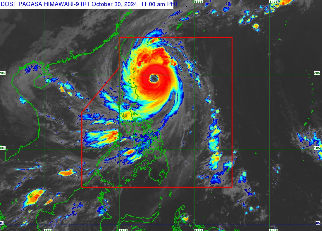
Tropical Cyclone Leon further intensified into a super typhoon as it threatens extreme northern Luzon, the state weather bureau said Wednesday.
In its tropical cyclone bulletin issued 11:00 a.m., the Philippine Atmospheric, Geophysical and Astronomical Services Administration (PAGASA) said the eye of “Leon” is located 350 kilometers east of Calayan, Cagayan.
Leon is moving west-northwestward at 10 kilometers per hour, with winds of 185 kph near its center and gusts of up to 230 kph.
PAGASA warns of strong to typhoon winds in areas under Tropical Cyclone Wind Signal (TCWS) No. 3:
- Batanes
- Eastern portion of Babuyan Islands (Babuyan Is., Camiguin Is., Calayan Is.,)
- Northeastern portion of mainland Cagayan (Santa Ana)
Gale-force winds will prevail over most of northern Luzon that are placed under TCWS No. 2:
- Rest of Babuyan Islands
- Rest of mainland Cagayan
- Northern and eastern portions of Isabela (Santo Tomas, Santa Maria, Quezon, San Mariano, Naguilian, Dinapigue, Delfin Albano, San Pablo, Ilagan City, Benito Soliven, Tumauini, Cabagan, Palanan, Quirino, Divilacan, Gamu, Mallig, Maconacon, Burgos, City of Cauayan, San Guillermo, Angadanan, Cabatuan, Luna, Reina Mercedes, Roxas, Aurora, San Manuel)
- Apayao
- Kalinga
- Northern and eastern portions of Abra (Tineg, Lacub, Malibcong, Lagayan, San Juan, Lagangilang, Licuan-Baay, Daguioman)
- Eastern portion of Mountain Province (Paracelis)
- Ilocos Norte
Strong winds will likely be experienced in the central and eastern sections of Luzon under TCWS No. 1:
- Rest of Isabela
- Quirino
- Nueva Vizcaya
- Rest of Mountain Province
- Ifugao
- Benguet
- Rest of Abra
- Ilocos Sur
- La Union
- Pangasinan
- Nueva Ecija
- Aurora
- Northeastern portion of Tarlac (Camiling, San Clemente, Paniqui, Moncada, Anao, San Manuel, Pura, Ramos, Victoria, Gerona, Santa Ignacia, City of Tarlac, La Paz)
- Northern portion of Bulacan (Doña Remedios Trinidad, San Miguel)
- Northern portion of Quezon (Infanta, General Nakar) including Polillo Islands
- Camarines Norte
- Northern portion of Camarines Sur (Siruma, Tinambac, Lagonoy, Garchitorena, Caramoan)
- Northern and eastern portions of Catanduanes (Pandan, Gigmoto, Bagamanoc, Panganiban, Viga, Baras, Caramoran)
“Wind Signal No. 4 will be hoisted over Batanes this afternoon in anticipation of potentially destructive typhoon-force winds from Leon,” PAGASA said.
The super typhoon will also bring gusty conditions in Bataan, Metro Manila, CALABARZON, MIMAROPA, Bicol Region, most of Visayas, and Dinagat Islands today.
Meanwhile, intense to torrential rains are also forecast to batter Batanes and Cagayan including Babuyan Islands until Thursday noon (Oct. 31); heavy to intense rains in Ilocos Norte, Apayao,
Isabela, and Occidental Mindoro; and moderate to heavy rains in Ilocos Sur, Abra, Kalinga, Benguet, La Union, Pangasinan, Calamian Islands, Negros Occidental, and Antique.
PAGASA also raised a storm surge warning over the low-lying, coastal localities of Batanes and Babuyan Islands.
A gale warning is likewise hoisted over the seaboard of Northern Luzon and the eastern seaboards of Central and Southern Luzon.
In its track forecast, PAGASA said Super Typhoon Leon will move northwestward and may be closest to Batanes between late Wednesday and Thursday morning.
A landfall scenario in the province is also not ruled out, the agency said.
Leon will make landfall along the eastern coast of Taiwan on Thursday afternoon and exit the Philippine Area of Responsibility (PAR) late Thursday or early Friday morning.
—iro
