
By Brian Campued
The low pressure area (LPA) east of Northern Luzon over the Philippine Sea has developed into Tropical Depression Julian on Friday morning, the Philippine Atmospheric, Geophysical, and Astronomical Services Administration (PAGASA) said.
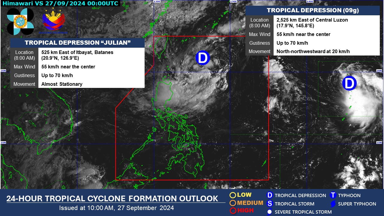
In its tropical cyclone bulletin issued at 11:00 a.m., PAGASA said Julian was located and remained “almost stationary” at 525 kilometers (km) east of Itbayat, Batanes.
The tropical depression packs maximum sustained winds of 55 kph near its center and gustiness of up to 70 kph.
According to PAGASA, Tropical Cyclone Wind Signal No. 1 may be raised over portions of Cagayan Valley within the day.
“The highest wind signal which may be hoisted during the occurrence of Julian is Wind Signal No. 2 or 3,” it said.
In its track forecast, the state weather bureau said Julian is forecast to follow a “looping path” or “V-shaped” track over the waters east of Batanes and Cagayan in the next five days.
“Initially, the tropical cyclone will head south southwestward or southwestward today and tomorrow (Sept. 28) while decelerating, then move slowly westward to northwestward on Sunday, before accelerating generally northward from Monday (Sept. 30) onwards,” the agency explained.
In a public briefing, PAGASA-Weather Division assistant weather services chief Engr. Christopher Perez said Julian will continue to intensify and reach the ‘Tropical Storm’ category on Friday night or Saturday morning, moving southwestward at 460 km east of Silayan, Cagayan.
“Sa darating na linggo, posibleng umabot pa itong severe tropical storm category,” Perez said.
“Bagamat walang landfall, magiging mabagal ang pagkilos to the point na Miyekroles nasa loob pa ng PAR,” he added.
Moderate to heavy rains are expected over Cagayan, Isabela, Batanes, Apayao, and Ilocos Norte until Sunday noon (Sept. 29).
The typhoon is not expected to enhance the southwest monsoon as the habagat season usually ends in September.
“Kung magkakaroon ng habagat episode ay hindi na po natin inaasahan katulad no’ng enhancement ni [Typhoon] Carina; however, puwede pang magkaroon ng pagbabago sa forecast scenario natin,” Perez said, reminding the public to monitor updates by PAGASA.
While no gale warning is hoisted yet in the country’s seaboards, mariners of small seacraft are advised not to sail as the sea condition may become rough to moderate along the seaboards of Batanes, Babuyan Islands, and the eastern seaboard of mainland Cagayan.
Meanwhile, the tropical depression outside the Philippine Area of Responsibility (PAR) was last spotted at 2,525 km east of Central Luzon, moving north-northwestward at 20 kph. —iro