
By Brian Campued
The low pressure area outside the Philippine area of responsibility (PAR) has developed into a tropical depression on Tuesday afternoon, according to the state weather bureau.
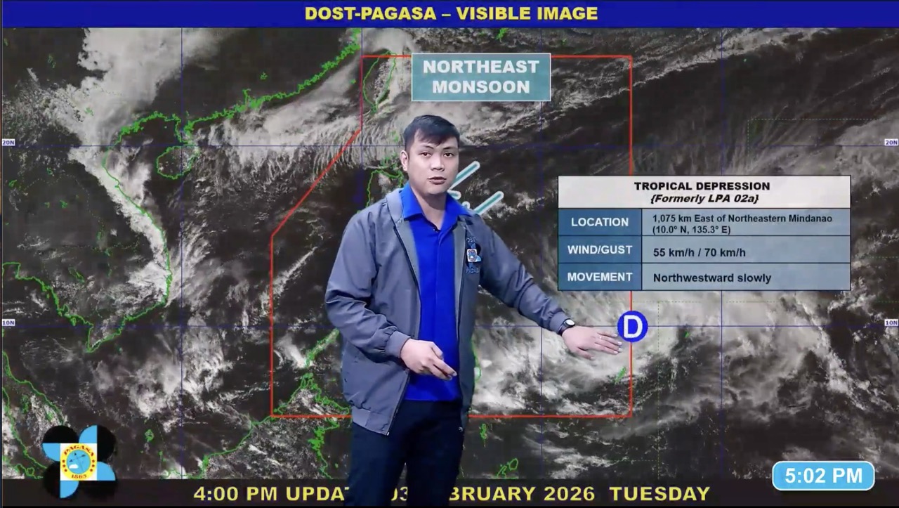
As of 4:00 p.m., the Philippine Atmospheric, Geophysical and Astronomical Services Administration (PAGASA) said the center of the tropical depression was monitored 1,075 km east of northeastern Mindanao.
It packs maximum sustained winds of 55 kph and gustiness of up to 70 kph while moving northwestward slowly.
According to PAGASA, the tropical cyclone will enter the PAR by Tuesday evening or early Wednesday morning and will be assigned the local name “Basyang”.
“Base sa ating forecast track, yung tropical depression niya na category ay mananatili hanggang bukas at by Thursday ng madaling araw, ito po ay mas lalakas pa from tropical depression into tropical storm,” PAGASA weather specialist John Manalo said in a public briefing, noting that Basyang will weaken back into a tropical depression by Saturday afternoon, Feb. 7, after traversing northeastern Mindanao.
He added that Tropical Cyclone Wind Signal No. 1 may be hoisted as early as Wednesday afternoon, noting the 36-hour lead time before the actual winds may be experienced in specific locations.
Manalo also said that cloud formations associated with the tropical cyclone may bring heavy rains over Northern Mindanao and Visayas, while the trough or the extension of these clouds may reach as far as Metro Manila.
The onset of heavy rains may be felt between Wednesday afternoon and Thursday afternoon, with moderate to heavy rains possible in Eastern Samar, Southern Leyte, Dinagat Islands, Surigao del Norte, Camiguin, Agusan del Norte, Surigao del Sur, Misamis Oriental, Agusan del Sur, Bukidnon, Davao de Oro, Davao del Norte, and Davao Oriental.
By Thursday afternoon to Friday afternoon, more areas will experience moderate to heavy rains, including parts of Central Visayas, Negros Island Region, Western Visayas, Zamboanga Peninsula, Northern Mindanao, Caraga, and Davao Region.
“Ang ibig sabihin po ng at least 50 mm [of rain] ay posible ang mga localized floodings and also, kung nakatira tayo sa mga landslide-prone area, ay posible rin na makaranas tayo, kaya heads up po,” Manalo said.
-av