
By Brian Campued
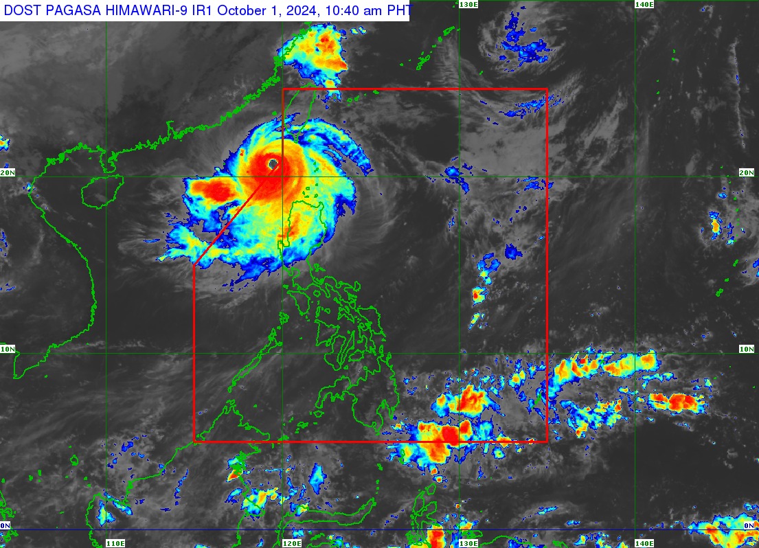
Super Typhoon Julian has left the Philippine Area of Responsibility (PAR) on Tuesday morning, but may re-enter by Wednesday, according to the Philippine Atmospheric, Geophysical and Astronomical Services Administration (PAGASA).
In its 11:00 a.m. tropical cyclone bulletin, the state weather bureau said the eye of the storm was last spotted at 235 kilometers (km) west of Itbayat, Batanes, moving “westward slowly.”
Julian, which intensified into a super typhoon early Tuesday morning, packs maximum sustained winds of 195 kilometers per hour (kph) near its center and gustiness of up to 240 kph.
“Although nasa labas ‘’yong kaniyang mata, nag-extend o nag-expand pa ang kaniyang diyametro so ngayon nakaaapekto pa rin ’yong bagyong ito sa malaking bahagi ng Northern Luzon,” PAGASA weather specialist Loriedin de la Cruz-Galicia said in a press briefing.
“Exposed pa rin ang extreme Northern Luzon at ilang bahagi ng Northern Luzon sa mga malalakas na pag-ulan, maging ‘yong mga malalakas na hangin na dulot at dala po ni Bagyong Julian,” De la Cruz-Galicia added.
In its track forecast, PAGASA said the super typhoon is forecast to recurve toward the PAR and make landfall along the southwestern coast of Taiwan Wednesday morning or afternoon. Julian is expected to exit the PAR on Thursday evening or early Friday morning.
Tropical Cyclone Wind Signal (TCWS) No. 2 is still hoisted in Batanes, Babuyan Islands, the northern portion of Ilocos Norte (Bacarra, Pasuquin, Bangui, Vintar, Burgos, Pagudpud, Dumalneg, Adams), and the northwestern portion of mainland Cagayan (Santa Praxedes, Claveria, Sanchez-Mira).
The rest of Ilocos Norte, Ilocos Sur, La Union, Pangasinan, Apayao, Kalinga, Abra, Mountain Province, Ifugao, Benguet, the rest of mainland Cagayan, Isabela, Quirino, Nueva Vizcaya, the northern portion of Aurora (Dilasag, Casiguran, Dinalungan), and the northern portion of Nueva Ecija (Carranglan, Lupao, Pantabangan) are placed under TCWS No. 1.
PAGASA also warned of strong to gale-force gusts in Ilocos Region, Cordillera Administrative Region (CAR), the northern and eastern portions of mainland Cagayan, the eastern portion of Isabela, Aurora, Zambales, Bataan, Metro Manila, Calabarzon, Romblon, and Camarines Norte.
There is also a “moderate to high risk” threat of storm surge in the next 48 hours over low-lying, coastal localities of Batanes and Babuyan Islands.
Meanwhile, a gale warning is raised in the northern and western seaboards of Northern Luzon, which is risky for all types of vessels.
In terms of rainfall, PAGASA said heavy to intense rains are expected over Batanes, Babuyan Islands, and Ilocos Norte until Wednesday noon; and moderate to heavy rains in mainland Cagayan, CAR, and the rest of Ilocos Region.
“Under these conditions, flooding and rain-induced landslides are likely, especially in areas that are highly or very highly susceptible to these hazards as identified in hazard maps and in areas with significant antecedent rainfall,” the state weather bureau said. —iro

