
By Brian Campued
Residents in Cagayan, Babuyan Islands, and nearby areas are warned as “Ofel”—now a super typhoon—is forecast to make at least two landfalls during its passage, the state weather bureau said Thursday.
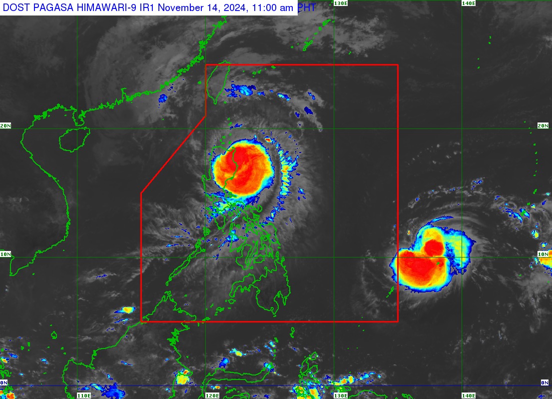
In its tropical cyclone bulletin issued at 11:00 a.m., the Philippine Atmospheric, Geophysical and Astronomical Services Administration (PAGASA) said Super Typhoon Ofel was located over the coastal waters of Divilacan, Isabela, moving west-northwestward at 15 kilometers per hour.
Ofel packs maximum sustained winds of 185 kph near the center and gustiness of up to 230 kph.
Due to its strength, PAGASA hoisted Tropical Cyclone Wind Signal (TCWS) No. 5 in the northeastern portion of mainland Cagayan (Santa Ana and Gonzaga), while Wind Signal No. 4 is raised over Babuyan Islands, the northern and eastern portions of mainland Cagayan (Santa Teresita, Ballesteros, Aparri, Camalaniugan, Buguey, Lal-lo, Allacapan, Gattaran, Baggao, and Peñablanca) and the northeastern portion of Isabela (Maconacon, Divilacan, and Palanan).
TCWS No. 3 is likewise hoisted in the following areas:
- Batanes
- Rest of Cagayan
- Northern, central, and southeastern portions of Isabela (San Pablo, Delfin Albano, Ilagan City, Tumauini, Cabagan, Santa Maria, Santo Tomas, San Mariano, Dinapigue)
- Northern portion of Apayao (Flora, Santa Marcela, Luna, Pudtol, Calanasan, Kabugao)
- Northern portion of Ilocos Norte (Pagudpud, Adams, Dumalneg)
TCWS No. 2:
- Western and southern portions of Isabela (Quezon, Quirino, Mallig, San Manuel, Aurora, Cabatuan, City of Cauayan, Benito Soliven, Naguilian, Gamu, Burgos, Reina Mercedes, Luna, Roxas, Angadanan, Alicia, San Guillermo, Echague, Jones, San Agustin, San Mateo, San Isidro)
- Northeastern portion of Quirino (Maddela)
- Rest of Apayao
- Kalinga
- Northeastern portion of Abra (Tineg, Lacub, Malibcong, Lagayan, San Juan, Lagangilang, Licuan-Baay, Daguioman)
- Eastern portion of Mountain Province (Paracelis)
- Eastern portion of Ifugao (Alfonso Lista)
- Rest of Ilocos Norte
- Northern portion of Aurora (Dilasag)
TCWS No. 1:
- Nueva Vizcaya
- Ilocos Sur
- Rest of Isabela
- Rest of Quirino
- Rest of Mountain Province
- Rest of Ifugao
- Rest of Abra
- Northern portion of Benguet (Bokod, Mankayan, Kapangan, Atok, Kabayan, Kibungan, Bakun, Buguias, Tublay)
- Northern portion of La Union (Luna, Sudipen, Bangar, Santol, San Gabriel, Bagulin, Bacnotan, Balaoan, San Juan)
- Northern and central portions of Aurora (Casiguran, Dinalungan, Dipaculao, Maria Aurora, Baler, San Luis)
In its track forecast, the state weather bureau said Ofel is expected to make landfall near or at peak intensity along the eastern coast of Cagayan Thursday afternoon, and possibly make another landfall or pass very close to Babuyan Islands Thursday evening.
“Regardless of the position of the landfall point, it must be emphasized that hazards on land and coastal waters may still be experienced in areas outside the landfall point and the forecast confidence cone,” PAGASA said.
Intense to torrential rains are likely to be experienced in Cagayan and Isabela until Friday noon; heavy to intense rains in Batanes, Ilocos Norte, Apayao, Mountain Province, Quirino, Aurora, and Kalinga; and moderate to heavy rains over Abra, Ifugao, and Nueva Vizcaya.
Aside from its very destructive winds and heavy rains, a “moderate to high” risk of storm surge (up to three meters) may be experienced in low-lying, coastal localities of Batanes, Ilocos Norte, Ilocos Sur, Cagayan (including Babuyan Islands), Isabela, and northern Aurora.
Gale warning is also hoisted along the northern and eastern seaboards of Northern Luzon and the eastern seaboard of Central Luzon.
‘Man-Yi’ to enter PAR as ‘Pepito’
Meanwhile, the tropical cyclone with the international name “Man-Yi” is forecast to enter the Philippine area of responsibility (PAR) Thursday evening as ‘Pepito’.
The tropical storm was last spotted 1,375 km east of Northeastern Mindanao, packing winds of 85 kph and gusts of up to 105 kph while moving west-southwestward at 25 kph.
According to PAGASA, Pepito will rapidly intensify and reach typhoon category Friday morning prior to possible landfall at peak intensity over the eastern coast of Southern Luzon on the weekend (Nov. 16 or 17).
PAGASA emphasized that the landfall point may also shift from the eastern coast of Central Luzon to the eastern coast of Eastern Visayas.
“Since this tropical cyclone may reach typhoon category while over the Philippine Sea, the possibility for Man-Yi to reach super typhoon category prior to landfall is also not ruled out,” the state weather bureau said.
—iro