
By Dean Aubrey Caratiquet
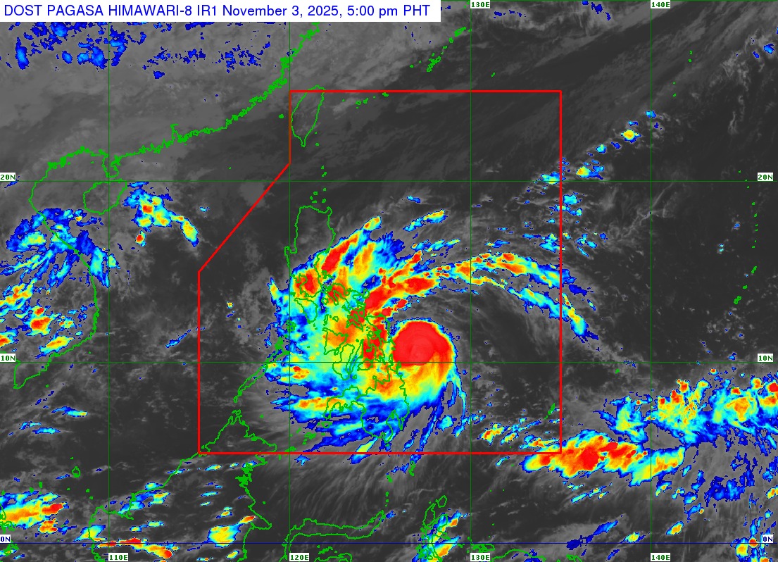
The Philippine Atmospheric, Geophysical, and Astronomical Services Administration (PAGASA) announced the upcoming landfall of Typhoon Tino within the next 24 hours as it hovers within the proximity of the Eastern Visayas-Caraga area, according to the agency’s 5:00 p.m. bulletin.
Tino (international name: Kalmaegi) was last located 170 km east southeast of Guiuan, Eastern Samar, packing maximum sustained winds of 130 kph near the center and gustiness of up to 160 kph, as it moves westward at 20 kph.
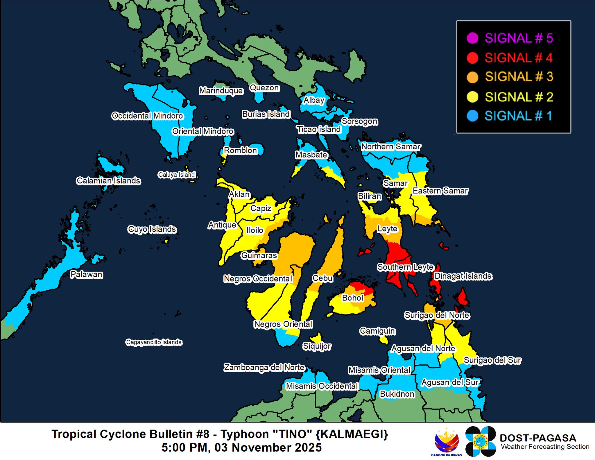
Due to its closer proximity to the Eastern Visayas-Caraga area, PAGASA has hoisted Tropical Cyclone Wind Signal (TCWS) No. 4 in the following areas:
- Extreme southeastern portion of Eastern Samar (Guiuan)
- Southern portion of Leyte (Mahaplag, Abuyog, City of Baybay, Inopacan, Hilongos, Hindang, Bato, Matalom, Javier)
- Southern Leyte
- Camotes Islands
- Northeastern portion of Bohol (Pres. Carlos P. Garcia, Getafe, Trinidad, Ubay, Bien Unido, Talibon)
- Dinagat Islands
- Siargao
- Bucas Grande Islands
Wind Signal No. 3:
- Southern portion of Eastern Samar (Mercedes, Lawaan, Balangiga, Giporlos, Quinapondan, Salcedo)
- Southern portion of Samar (Marabut)
- Central portion of Leyte (Tanauan, Palo, Tabontabon, Isabel, Merida, Palompon, Ormoc City, Dagami, Pastrana, Burauen, Albuera, Macarthur, La Paz, Mayorga, Dulag, Julita, Tolosa, Matag-Ob, Villaba, Kananga, Jaro)
- Northern and central portions of Cebu (Borbon, Sogod, Catmon, Carmen, Danao City, Compostela, Liloan, Lapu-Lapu City, Cordova, Consolacion, Mandaue City, Cebu City, Asturias, Balamban, Tuburan, Tabuelan, Tabogon, City of Talisay, City of Bogo, San Remigio, Medellin, Daanbantayan, Sibonga, City of Carcar, San Fernando, City of Naga, Minglanilla, Toledo City, Aloguinsan, Pinamungahan, Barili, Dumanjug) including Bantayan Islands
- Central and eastern portions of Bohol (San Miguel, Mabini, Buenavista, Inabanga, Danao, Dagohoy, Guindulman, Pilar, Alicia, Candijay, Anda, Jagna, Duero, Sierra Bullones, Carmen, Sagbayan, Clarin, Tubigon)
- Northern portion of Negros Oriental (Vallehermoso, Canlaon City, City of Guihulngan)
- Northern portion of Negros Occidental (Hinigaran, Moises Padilla, Isabela, La Castellana, Pontevedra, San Enrique, La Carlota City, Cadiz City, Bago City, Enrique B. Magalona, Toboso, Valladolid, Salvador Benedicto, Sagay City, Bacolod City, Murcia, City of Escalante, Calatrava, San Carlos City, Silay City, Pulupandan, City of Victorias, City of Talisay, Manapla)
- Guimaras
- Eastern portion of Iloilo (Concepcion, Barotac Nuevo, Ajuy, Iloilo City, Anilao, Barotac Viejo, Leganes, Zarraga, Dumangas, Banate)
- Rest of Surigao del Norte
Wind Signal No. 2:
- Southern portion of Masbate (Esperanza, Pio V. Corpuz, Placer, Balud, Cawayan)
- Southern portion of Romblon (San Jose, Santa Fe, Alcantara, Looc), and Cuyo Islands
- Central portion of Eastern Samar (Can-Avid, City of Borongan, Taft, Llorente, Maydolong, Balangkayan, Sulat, San Julian, General Macarthur, Hernani)
- Central portion of Samar (San Sebastian, Santa Rita, Villareal, Zumarraga, Pinabacdao, Talalora, Jiabong, City of Catbalogan, Motiong, Calbiga, Daram, Paranas, Basey, Hinabangan, Santo Niño, Almagro, Tarangnan)
- Rest of Leyte
- Biliran
- Rest of Bohol
- Rest of Cebu
- Central portion of Negros Oriental (Tayasan, Manjuyod, City of Tanjay, Bais City, Mabinay, Bindoy, Ayungon, Jimalalud, La Libertad, Sibulan, San Jose, Amlan, Pamplona, City of Bayawan, Basay, Valencia, Dumaguete City, Bacong)
- Rest of Negros Occidental
- Siquijor
- Capiz
- Rest of Iloilo
- Aklan
- Antique
- Northern portion of Surigao del Sur (Carrascal, Cantilan, Madrid, Carmen, Lanuza, Cortes, Tago, San Miguel, Marihatag, Cagwait, Bayabas, City of Tandag)
- Northern portion of Agusan del Sur (Sibagat)
- Northern portion of Agusan del Norte (Kitcharao, Jabonga, Santiago, Tubay, City of Cabadbaran, Remedios T. Romualdez, Magallanes)
- Camiguin
Wind Signal No. 1:
- Albay
- Sorsogon
- Rest of Masbate (including Ticao and Burias Islands)
- Southern portion of Quezon (San Francisco, San Andres)
- Southern portion of Marinduque (Torrijos, Buenavista, Gasan, Boac)
- Rest of Romblon
- Oriental Mindoro
- Occidental Mindoro
- Northern and central portions of Palawan (El Nido, Taytay, Dumaran, Araceli, San Vicente, Roxas, Puerto Princesa City, Aborlan) including Calamian Islands and Cagayancillo Islands
- Northern Samar
- Rest of Eastern Samar
- Rest of Samar
- Rest of Negros Oriental
- Rest of Surigao del Sur
- Central portion of Agusan del Sur (City of Bayugan, Prosperidad, Esperanza, San Luis, Talacogon, San Francisco, Rosario)
- Rest of Agusan del Norte
- Misamis Oriental
- Northern portion of Bukidnon (Baungon, Malitbog, Impasug-Ong, Libona, Manolo Fortich, Sumilao)
- Northern portion of Misamis Occidental (Baliangao, Plaridel, Sapang Dalaga, Calamba, Lopez Jaena, Concepcion, Oroquieta City, Aloran)
- Northern portion of Zamboanga del Norte (Sibutad, Rizal, Dipolog City, Manukan, Pres. Manuel A. Roxas, Katipunan, Polanco, Dapitan City, Piñan, La Libertad, Mutia, Jose Dalman)
PAGASA has also issued a gale warning advisory over several seaboards in Luzon, Visayas, and Mindanao, noting risky travel for all types of vessels due to very rough seas and high waves in these coastal waters:
- Up to 9.0 m: The eastern seaboard of Eastern Samar
- Up to 7.0 m: The eastern seaboard of Dinagat Islands; the northern and eastern seaboards of Siargao and Bucas Grande Islands
- Up to 6.0 m: The seaboard of Antique and Cuyo Islands; the eastern seaboards of northern mainland Palawan, Calamian Islands, and Leyte; the southern seaboards of Occidental Mindoro, Oriental Mindoro, and Samar; the northern seaboard of Dinagat Islands; the western seaboard of Aklan; the remaining seaboard of Eastern Samar
- Up to 5.0 m: The seaboard of Capiz; the northern and eastern seaboards of Northern Samar, northern Cebu including Bantayan and Camotes Islands; the northern seaboard of Negros Occidental; the western seaboards of Leyte and Dinagat Islands, the eastern seaboards of Sorsogon, Southern Leyte, and northern Iloilo; the southern seaboards of Masbate and Romblon; the remaining seaboard of Aklan
- Up to 4.5 m: The seaboards of Camarines Norte, Albay, Biliran, Agusan del Norte, and Camiguin; the northern and eastern seaboards of Polillo Islands and Catanduanes; the northern and western seaboards of Surigao del Norte; the northern seaboard of Camarines Sur; the eastern seaboard of mainland Cagayan and Oriental Mindoro; the remaining seaboards of Sorsogon, Romblon, Masbate, and Visayas
Rough seas are also expected over the following coastal waters:
- Up to 4.0 m: The seaboards of Batanes, Babuyan Islands, Ilocos Norte, Ilocos Sur, Isabela, Aurora, northern mainland Quezon, and Cagayancillo Islands; the remaining seaboards of mainland Cagayan and Caraga Region.
- Up to 3.5 m: The eastern seaboard of Camarines Sur; the remaining seaboard of Catanduanes.
- Up to 3.0 m: The seaboard of La Union, Marinduque, and Surigao del Sur; the western seaboards of Pangasinan, Occidental Mindoro, northern mainland Palawan, and Calamian Islands; the eastern seaboard of Davao Oriental; the remaining seaboards of Quezon, Bicol Region, and Northern Mindanao.
Typhoon Tino is expected to make landfall or pass very close to Homonhon Island or Dinagat Islands on Monday night or Tuesday morning (Nov. 4), and may make another landfall over Leyte or Southern Leyte, then going on to traverse Visayas and Northern Palawan throughout Tuesday before emerging on the West Philippine Sea on Wednesday (Nov. 5).
PAGASA notes that the weather system’s may make landfall at or near peak intensity, citing the possibility of rapid intensification before interacting with the terrain of Eastern Visayas.
LGUs told to facilitate evacuations ahead of Typhoon Tino’s landfall
With Typhoon Tino’s upcoming landfall expected over the next 24 hours, the Department of the Interior and Local Government (DILG) urged all local government units (LGUs) in high-risk areas to immediately carry out pre-emptive or mandatory evacuations in anticipation of widespread flooding, landslides, and storm surges brought about by the storm.
In an advisory on Monday, the agency reminded LGUs to ensure the readiness of minimum critical preparedness measures and continuously monitor PAGASA’s weather updates to disseminate timely alerts using all available communication platforms to their constituents.
Likewise, Local Disaster Risk Reduction and Management Councils must be convened to conduct Pre-Disaster Risk Assessment (PDRA) meetings, closely monitor river water levels, and enforce the no-sailing policy, prohibiting sea travel and small-scale fishing when gale warnings are issued.
av