
By Dean Aubrey Caratiquet
In a bid to streamline information related to natural disasters, the government launched an integrated web portal on Monday that enables easier access to such crucial data.
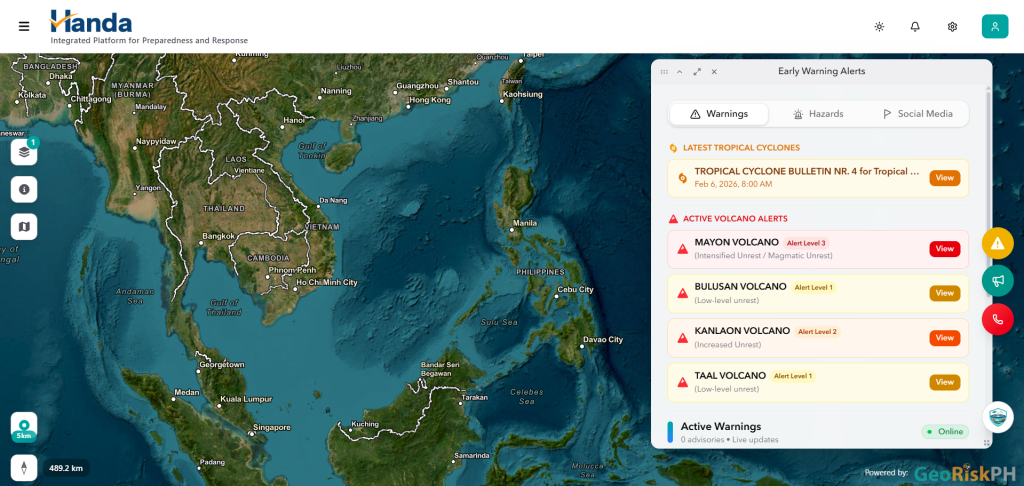
The website is called “Handa: Integrated Platform for Preparedness and Response”, and can be accessed in any browser via handa.georisk.gov.ph.
This initiative was made possible through the efforts of the Department of Science and Technology (DOST), with further help from the Philippine Institute of Volcanology and Seismology (Phivolcs).
This integrated platform serves as a unified system for early warning, disaster preparedness, and response—packed with various features to make disaster-related information easier to understand for the common folk.
Upon initially opening the website, a pop-up will walk users through the different user interface elements that they can interact with to find the information that they need.
An interactive map will show real-time hazard data around the user’s location, which can be navigated akin to Google or Apple Maps.
Delving deeper, map layers can also be toggled to determine hazard zones, locate evacuation centers and health facilities, and even display a color-coded hazard severity level—all of which can be further decoded using the map legends button.
The map background can likewise be adjusted to showcase different imagery, which includes satellite view, navigation view, topographic view, and a dark mode feature to avoid searing your retinas at night.
A search radius button may also be used to help the user navigate a section of the map using a user-determined coverage area or quick presets such as 5, 10, 50, 100, and 500 km.
Citizens may also submit an incident report in their vicinity by tapping/clicking the green button with a megaphone symbol, and call for help by contacting authorities using the emergency SOS feature (red button with a telephone symbol).
A yellow button with an exclamation mark enclosed in a white triangle may also be tapped/clicked to display real-time hazard advisories on the map.
Finally, the website is equipped with an AI assistant toggle that users can interact with to ask for the nearest evacuation centers and safe open spaces in any area, and learn tips on how to prepare for any contingency.
jpv