By Brian Campued
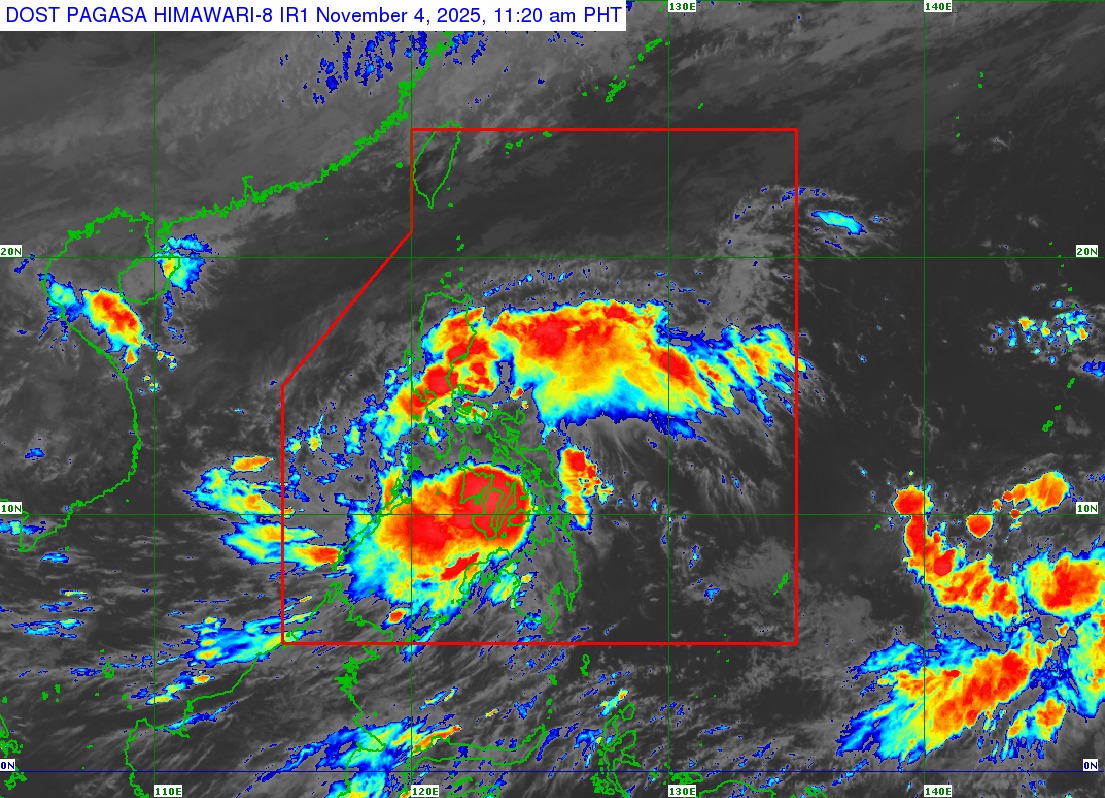
The low pressure area being monitored outside the Philippine area of responsibility (PAR) has developed into a tropical depression while Typhoon Tino (international name: Kalmaegi) slightly weakened as it continues to threaten Western Visayas and Negros Island Region.
As of 10:00 a.m. this Tuesday, the Philippine Atmospheric, Geophysical and Astronomical Services Administration (PAGASA) said the center of Typhoon Tino was spotted in the vicinity of Bacolod City, Negros Occidental.
Tino packs maximum sustained winds of 140 kph and gustiness of up to 195 kph. It is moving westward at 25 kph.
According to PAGASA weather specialist John Manalo, the typhoon has made four landfalls—Silago, Leyte at 12:00 a.m.; Borbon, Cebu at 5:10 a.m.; Sagay City, Negros Occidental at 6:40 a.m.; and San Lorenzo, Guimaras at 11:10 a.m.
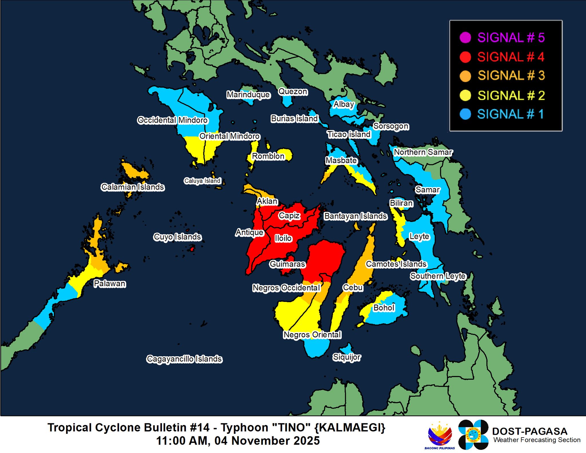
Tropical Cyclone Wind Signal (TCWS) No. 4 remains in effect over Cuyo Islands in Palawan, the northernmost portion of Negros Oriental, northern portion of Negros Occidental, Guimaras, Capiz, Iloilo, the central and southern portions of Antique, and the southern portion of Aklan.
TCWS No. 3 is likewise hoisted over the southwestern portion of Masbate, northernmost portion of Palawan including Calamian Islands, northern and central portions of Cebu including Bantayan Islands, northernmost portion of Negros Oriental, northern portion of Negros Occidental, the rest of Aklan, and the rest of Antique including Caluya Islands.
Wind Signal No. 2 are raised in the western and southern portions of Masbate, southern portion of Oriental Mindoro, southern portion of Occidental Mindoro, southern portion of Romblon, northern portion of Palawan including Cagayancillo Islands, western portion of Biliran, western portion of Leyte, northwestern portion of Bohol, the rest of Cebu including Camotes Islands, central portion of Negros Oriental, and the rest of Negros Occidental.
Signal No. 1 is also up in the southern portion of Quezon, southern portion of Marinduque, rest of Oriental Mindoro, northern and central portions of Occidental Mindoro, rest of Romblon, western and southern portions of Albay, western and southern portions of Sorsogon, rest of Masbate including Burias and Ticao Islands, central portion of Palawan, western portion of Northern Samar, western portion of Samar, rest of Biliran, the rest of Leyte, northern and western portions of Southern Leyte, rest of Bohol, rest of Oriental Mindoro, and Siquijor.

Residents in areas under Wind Signals are warned of possible strong to typhoon-force winds that may cause minimal to severe impacts to life and property.
In terms of rainfall, PAGASA said Typhoon Tino will dump intense to torrential rains over Palawan, Negros Occidental, Antique, Aklan, Iloilo, Guimaras, and Capiz until Wednesday noon (Nov. 5) while heavy to intense rains are forecast over Cebu, Occidental Mindoro, Oriental Mindoro, Bohol, Siquijor, Negros Oriental, and Romblon.
Camarines Norte, Camarines Sur, Batangas, Catanduanes, Albay, Sorsogon, Marinduque, Masbate, Northern Samar, Samar, Eastern Samar, Biliran, Southern Leyte, Leyte, Dinagat Islands, Camiguin, Surigao del Norte, Lanao del Sur, Misamis Occidental, Zamboanga del Norte, Lanao del Norte, Agusan del Norte, and Misamis Oriental will likewise experience moderate to heavy rains during the same period.
Residents in low-lying or coastal communities in Masbate, Romblon, Oriental Mindoro, Occidental Mindoro, Palawan, Western Visayas, Negros Island Region, Central Visayas, Eastern Visayas, Dinagat Islands, and Camiguin are urged to stay away from the coast or beach, cancel all marine activities, and move to higher ground due to possible storm surge exceeding 3 meters.
Mariners are also advised to remain in port or seek safe harbor, if already at sea, due to rough to high, very high, or phenomenal seas over the eastern seaboard of Northern Luzon, the eastern and southern seaboards of Southern Luzon, the seaboards of Visayas, and the northern and eastern seaboards of Mindanao.
According to the state weather bureau, Typhoon Tino is forecast to continue traversing Western Visayas and northern Palawan before exiting the PAR on Wednesday evening or Thursday morning (Nov. 6).
“Sa mga susunod na oras ay babaybayin niya (Typhoon Tino) o muli siyang magla-landfall sa may Panay Islands, and eventually ay dadaan siya sa Sulu Sea at pupunta na siya sa northern portion ng Palawan. Posible ito na mag-landfall sa ilang islands sa Palawan,” Manalo said.
Meanwhile, the tropical depression outside PAR was last seen 2,050 km east of northeastern Mindanao as of 8:00 a.m. on Tuesday. It will be given the name “Uwan”.
The state weather bureau said potential Uwan may further intensify while over the Philippine Sea and reach typhoon category by the time it enters the PAR between Friday evening (Nov. 7) or Saturday morning (Nov. 8).
-jpv
