
By Brian Campued
Intense rains are still expected over the western portion of Luzon in the next two days as Tropical Depression Neneng, despite its slight weakening, continues to enhance the southwest monsoon (habagat).
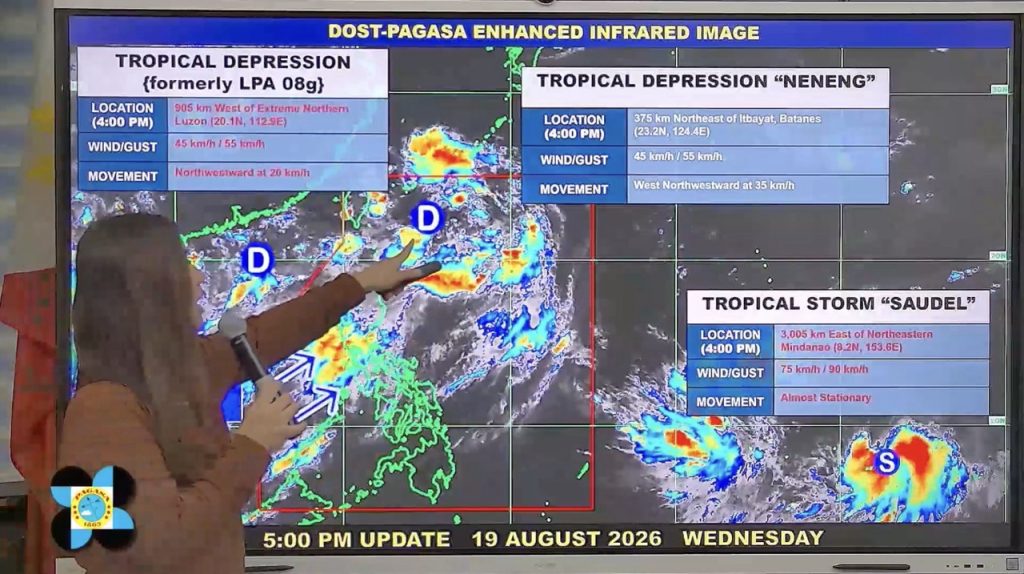
Based on the 5:00 p.m. bulletin issued by the Philippine Atmospheric, Geophysical and Astronomical Services Administration (PAGASA) this Wednesday, Tropical Depression Neneng was last monitored 375 km northeast of Itbayat, Batanes.
The tropical cyclone still packs maximum sustained winds of 45 kph near the center and gustiness of up to 55 kph while moving rapidly west-northwestward at 35 kph over the sea east of Central Taiwan.
“Sa ngayon kung makikita po natin, may distansya po ito sa ating kalupaan, hindi po nakakaabot sa extreme northern Luzon yung kanyang hangin at mga pag-ulan so wala po itong direct impact sa anumang bahagi ng ating bansa,” PAGASA Weather Specialist Loriedin de la Cruz-Galicia said in a public briefing.
“Pero ang nakikita po nating influence nito sa weather condition ngayon ay nae-enhance po niya ang habagat o southwest monsoon, at itong southwest monsoon po ang nagdudulot ng malawakang pag-ulan sa malaking bahagi ng Luzon at ilang bahagi ng Western Visayas,” she added.
Due to the cyclone remaining far from the Philippine landmass, no wind signal is hoisted on any parts of the country but the southwest monsoon will bring strong to gale-force gusts over most of Luzon and Visayas, Zamboanga Peninsula, Northern Mindanao, and Davao Region until Thursday, Aug. 20.
The enhanced habagat is likewise forecast to bring heavy to intense rains (100-200 mm) over Pangasinan, Zambales, and Bataan until Thursday afternoon, while moderate to heavy rains (50-100 mm) may drench Metro Manila, Ilocos Norte, Ilocos Sur, La Union, Abra, Benguet, Tarlac, Pampanga, Bulacan, Nueva Ecija, Cavite, Batangas, Laguna, Rizal, and Occidental Mindoro.
The state weather bureau reminded the public that forecast rainfall may be higher in mountainous and elevated areas while impacts in some areas “may be worsened by significant antecedent rainfall.”
Parts of Visayas and the entire Mindanao, on the other hand, will continue to experience hot and dry conditions due to the presence of an “anticyclone” or high-pressure area at the southeastern portion of the Philippine area of responsibility (PAR).
“Very concentrated yung mga pag-ulan sa Luzon, habang dito naman sa ilang bahagi ng Visayas at Mindanao ay halos walang mga pag-ulan,” de la Cruz-Galicia said.
As Neneng moves generally northwestward towards the northern coast of Taiwan on Thursday, the state meteorologist said it will pull the southwest monsoon, causing a shift in the direction of the habagat towards the northern portion of Luzon.
Due to this, moderate to heavy rains may persist over Batanes, Ilocos Norte, Ilocos Sur, La Union, Pangasinan, Zambales, and Bataan between Thursday afternoon to Friday afternoon, Aug. 21.
Neneng will remain a tropical depression in the next 24 hours before weakening into a remnant low over or near Taiwan on Friday.
Meanwhile, the two other tropical cyclones being monitored by PAGASA outside PAR currently have no direct effect on the country.
A tropical depression was located 905 km west of extreme northern Luzon while a tropical storm with international name “Saudel” was last spotted 3,005 km east of northeastern Mindanao.
-jpv

